Methodology
Itineraries and counts
The BMS technique is based on visual counts of adult butterflies along fixed routes. The transect is walked once a week at a constant speed, and only butterflies at a distance of five meters in front and to the sides of the observer are counted.
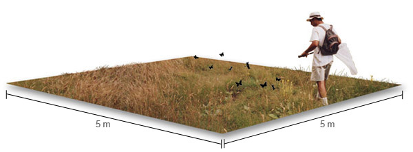
The sampling area extends two and a half meters to the sides and five meters in front of the observer.
The itinerary is divided into different sections (around 7–10 sections in most cases), each corresponding to a particular habitat type. Generally, CBMS transects are 1.5–2-km long. The time required for a census varies depending on the time of the year, but it usually ranges from 1–3 hours.
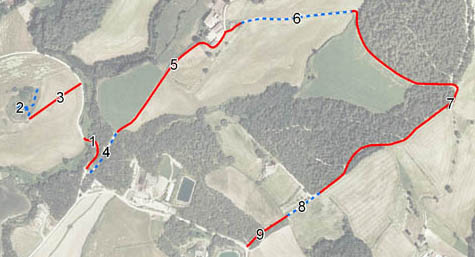
Sections of transect 29 in Marata, Vallès Oriental county
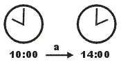
Counts are carried out during the morning, at any time between 10 am and 2 pm, as long as the weather conditions are favourable. Cloud cover is expressed as a percentage from observations collected in each section, and wind speed is estimated at the beginning and the end of the census according to the Beaufort scale.
In general, counts are not considered valid if the wind exceeds force 4 or if cloud cover exceeds 50% (in this latter case, butterfly activity decreases markedly even under a high ambient temperature). Ultimately, the decision on whether or not to include a sample if the environmental conditions are not optimal is based on a comparison with the results obtained in the previous and subsequent weeks. This comparison makes it possible to detect abnormally low values (both for individual species and for the whole community) when environmental conditions do not meet the minimum requirements.
Data are collected in specially designed recording field sheets. The basic information is the number of individuals of each species recorded per section. Additionally, interesting behavioural data (e.g. egg-laying, nectar sources, intra- and interspecies interactions, etc.) can be collected, as long as this does not hinder the primary activity. The field sheet includes a comments section for noting this type of additional information (see Recommendations for filling the recording field sheets).
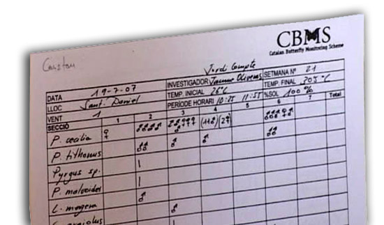
Detail of a recording field sheet
The official data collection period spans for 30 weeks, from the first week of March to the last week of September. Several methods can be used to estimate values for missing weeks (e.g. based on a simple arithmetic mean between counts of the previous and following weeks; or based on more complex methodologies, such as GAM models). In any case, it is recommended not to lose data for two or more consecutive weeks and, throughout the season, to not to lose data for more than 6 weeks. In some localities, counts extend into October and November, but these additional data are not used in the standard calculations of the annual index of abundance (see below).
Although most butterflies can be reliably identified without having to catch them, identification problems can arise in taxonomically close species groups. Some blues (Lycaenidae) and fritillaries (Nymphalidae) are particularly difficult to identify (e.g. those of the genera Melitaea and Argynnis), as well as most species of skippers (Hesperiidae). The inclusion of these difficult taxa at species level depends on the experience of the recorder and his/her knowledge of the local fauna. Sometimes, identification problems appear only between females of certain species. In such a case, counts to species level are only made for males, while females remain identified only to genus level (e.g. in Gonepteryx rhamni and G. cleopatra, females are counted as Gonepteryx sp., and in Lysandra bellargus, L. coridon and L.hispana females are counted as Lysandra sp.).
Finally, it should be noted that the method provides inaccurate abundance data for markedly arboreal species (e.g. Favonius quercus, Satyrium w-album, Thecla betulae). However, counts of these species are likely to correlate with their population levels.
Recording of additional variables
It is very important to have detailed records of any environmental impact affecting the transect, as this information is very valuable for interpreting population fluctuations. Among the most frequently recorded anthropogenic impacts is the use of pesticides and herbicides in agricultural areas, mowing and grazing in meadows, and roadside clearing and weeding. Natural impacts include the occurrence of storms with floods, snowfalls, etc. These impacts can be systematically recorded with the help of the impact sheet.
As well, since 2000 a periodical characterization of plant communities along the transects has taken place, the aim of which is to register changes occurring in the habitats of each section. This characterization is carried out by a skilled botanist and is updated every six years.
Some practical tips for carrying out transect counts

The CBMS season begins on March 1 and ends on September 26, and lasts for a total of 30 weeks (see the official calendar). Transects must be walked once a week, but not necessarily on the same day. However, it is always preferable to carry out the counts in the first days of the week to avoid the risk of losing the sample in the event that weather conditions deteriorate as the week progresses.
It is important to make the counts under sunny conditions, especially during the first months of the season, when air temperatures are still low. Otherwise, butterflies are not active and may go unnoticed. Counts should also be avoided if a strong and/or cold wind is blowing, when butterfly activity also decreases dramatically. In the first months (March and April) it is recommended to start counts around 12–13 h. Later in the season, when temperatures rise significantly (e.g. from May to June), counts can start earlier. In the middle of summer, it is preferable to advance the count to the early morning to avoid high temperatures that also affect butterfly activity.
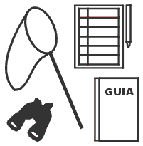
Additional material for sampling: butterfly net, binoculars, field guide and field recording sheets.
It is also important to use a butterfly net, which will allow you to capture and carefully examine difficult specimens for identification before being released. If identification doubts remain, it is recommended to take a photograph of the specimen and send it to the technical coordinator of the project, or to post a message on the project’s forum. In both cases you will receive the necessary support to identify the butterfly and find out what the distinctive identification features are for future occasions. Short-range binoculars are also a very helpful tool in transect counts, although using a butterfly net and handling specimens is the quickest way to learn.
If you pick up a butterfly for examination or follow it away from the transect, you stop counting. Remember the point where you left the route to be able to return later to resume sampling. It is very important to always follow exactly the same recording route. Typically, there is a tendency to count at a greater distance when the density of a species is low (e.g. at the beginning of a generation’s emergence) and to reduce this distance when butterflies become more abundant. This is a serious error, because in this way a bias is introduced in the detectability of the species throughout its flight period. To facilitate the maintenance of a constant counting distance it is recommended to use natural boundaries (e.g. roadsides, etc.) as a reference.
Recommended references
- Wiemers, M., Chazot, N., Wheat, C. W., Schweiger, O., & Wahlberg, N. (2020). A complete time-calibrated multi-gene phylogeny of the European butterflies. ZooKeys, 938, 97.
Web map | Legal notes | Credits
Project in agreement with:


In collaboration with:

