Aquesta web utiliza cookies tècniques, de personalització i anàlisi, pròpies i de tercers, per facilitar-li la navegació de forma anònima i analitzar estadístiques de l'ús de la web.
Considerem que, si continua navegant, n'accepta el seu ús. Obtenir més informació
i
Fals faune (Arethusana arethusa) - Pau Ortega i Colet
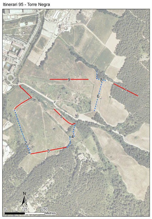
Itinerari situat a Sant Cugat del Vallès, al Vallès Occidental, a la cara nord de la Serra de Collserola. Consta de 9 seccions, amb una longitud total de 1.816 metres, i es troba situat a una alçada de 119 metres. Els comptatges es van iniciar l'any 2007 fins al 2011, reprenent-se puntualment el 2014 i de nou l'any 2019 fins a l'actualitat.
Ubicat a l'emblemàtica zona del Pi de'n Xandri i la finca de Torre Negra, es tracta d'un clar exemple d'abandonament de conreus i prats mediterranis que s'han tancat i transformat en matollars. L'itinerari també recorre seccions amb pineda i alzinar, i camins amb vegetació ruderal.
Sampling and data series
Years with data: 13 [2007-2011,2014,2019-2025] Recorded species: 54 (Annual average: 33) Recorded individuals : 17853 (Annual average: 1373) Number of recording samples: 262
Climatic variables
Average annual temperature: 15 ºC Average of January minima: 4 ºC Average of July maxima: 29 ºC Annual precipitation: 587 mm
Phenology
The bars show the weekly average butterfly abundance (calculated as the number of specimens per 1000 m) for the set of species recorded in the transect. Dots correspond to the weekly average number of species.
Habitats
The graph shows the relative cover of each habitat type in the whole transect. Since 2000, a botanical characterization has been performed for each itinerary every six years. For itineraries with more than one botanical characterization, you can change from one to another by clicking on the year of characterization.
2020
2014
2008
Sections
The map shows the transect route and the layout of the different sections. The background photograph corresponds to the 1:5000 orthophoto from the Cartographic Institute of Catalonia (ICGC).
Species occurring in this transect
Click to the Table to see the species list ordered by the abundance index average standardized at 100 m. Also, there is the trend each species follows in this itinerary. If you click the trend of any species you will enter Species by itinerary results. For more information about the index and trends calculation see Data analysis