90 - Estoll
Itinerari a la plana de la Cerdanya, molt pròxim al riu Segre. Té una longitud total de 2.141 metres i es divideix en 9 seccions. Es troba a 1.092 metres d'alçada i s'hi van realitzar comptatges complets des de l’any 2006 al 2019, i parcials el 2021. El 2024 s'ha reprès de nou aquest transsecte.
Es tracta d’un itinerari fonamentalment agrícola, amb una representació elevada de camps conreats amb cereals i de pastures intensives, intercalats amb taques de petites masses forestals de caducifolis que li donen una elevada diversitat faunística.
Sampling and data series
Years with data: 17 [2006-2019,2021,2024-2025] |
Climatic variables
Average annual temperature: 9 ºC |
Phenology
The bars show the weekly average butterfly abundance (calculated as the number of specimens per 1000 m) for the set of species recorded in the transect. Dots correspond to the weekly average number of species.
Habitats
The graph shows the relative cover of each habitat type in the whole transect. Since 2000, a botanical characterization has been performed for each itinerary every six years. For itineraries with more than one botanical characterization, you can change from one to another by clicking on the year of characterization.
Sections
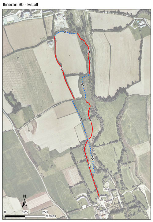
The map shows the transect route and the layout of the different sections. The background photograph corresponds to the 1:5000 orthophoto from the Cartographic Institute of Catalonia (ICGC).
Species occurring in this transect
Click to the Table to see the species list ordered by the abundance index average standardized at 100 m. Also, there is the trend each species follows in this itinerary. If you click the trend of any species you will enter Species by itinerary results. For more information about the index and trends calculation see Data analysis


Illustrations by Richard Lewington from Tolman & Lewington (1997) Butterflies of Britain and Europe, translated and published in Spanish by Lynx Edicions.
Change sheet
Characteristics
UTM10x10: 31T DG09
Province: Lleida
County: Cerdanya
Municipality: Fontanals de Cerdanya
Climatic region:
Alpí i subalpí
Number of sections: 8
Total length: 2141 m
Average length: 267 m
Average altitude: 1092 m
Participants: J Dantart, J Monterde
Web map | Legal notes | Credits
Project in agreement with:


In collaboration with:

