Aquesta web utiliza cookies tècniques, de personalització i anàlisi, pròpies i de tercers, per facilitar-li la navegació de forma anònima i analitzar estadístiques de l'ús de la web.
Considerem que, si continua navegant, n'accepta el seu ús. Obtenir més informació
i
Fals faune (Arethusana arethusa) - Pau Ortega i Colet
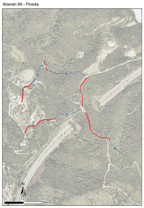
Situat a Pineda de Mar, al Maresme, és un itinerari que consta de 9 seccions, una longitud total de 1.731 metres i es troba a una alçada de 140 metres. L’itinerari es va realitzar un primer any el 2006, recomençant de nou el 2011 i mantenint-se actiu fins a l'actualitat.
Es troba en una zona d’alzinar mediterrani situada en el vessant marítim de la Serralada Litoral. L’itinerari discorre principalment per masses forestals (alzinar i pinedes) al voltant de l’ermita de Sant Pere de Riu, però també hi són presents, en menor mesura, alguns espais oberts i matollars.
Sampling and data series
Years with data: 16 [2006,2011-2025] Recorded species: 60 (Annual average: 38) Recorded individuals : 23933 (Annual average: 1496) Number of recording samples: 425
Climatic variables
Average annual temperature: 15 ºC Average of January minima: 4 ºC Average of July maxima: 28 ºC Annual precipitation: 749 mm
Phenology
The bars show the weekly average butterfly abundance (calculated as the number of specimens per 1000 m) for the set of species recorded in the transect. Dots correspond to the weekly average number of species.
Habitats
The graph shows the relative cover of each habitat type in the whole transect. Since 2000, a botanical characterization has been performed for each itinerary every six years. For itineraries with more than one botanical characterization, you can change from one to another by clicking on the year of characterization.
2025
2019
2013
2007
Sections
The map shows the transect route and the layout of the different sections. The background photograph corresponds to the 1:5000 orthophoto from the Cartographic Institute of Catalonia (ICGC).
Species occurring in this transect
Click to the Table to see the species list ordered by the abundance index average standardized at 100 m. Also, there is the trend each species follows in this itinerary. If you click the trend of any species you will enter Species by itinerary results. For more information about the index and trends calculation see Data analysis
UTM10x10: 31T DG71 Province: Barcelona County: Maresme Municipality: Pineda de Mar, Santa Sussanna, Tordera Protected area: Serres de Montnegre-el Corredor Climatic region: Mediterrani humit
Number of sections: 9 Total length: 1731 m Average length: 192 m Average altitude: 140 m