80 - Vall d'Horta
Itinerari situat a Sant Llorenç Savall, al Parc Natural de Sant Llorenç del Munt i l’Obac. Té un total de 10 seccions i una longitud de 2.260 metres, i es troba a una alçada de 516 metres. Es realitza regularment des de l’any 2005.
Recorregut en una zona amb un mosaic de pinedes de pi blanc i conreus, que va ser molt afectada per l’incendi forestal de Sant Llorenç del Munt l’agost de 2003. Al llarg dels darrers anys hi ha hagut canvis en les pràctiques agrícoles i de l'ús del sòl incloent cultius de vinya i la presència cada vegada més estesa de matollars en les zones on s'ha abandonat el cultiu. El creixement desmesurat de la vegetació post-incendi a la vessant de la secció 4 ha provocat un tancament de l'hàbitat inicial amb la conseqüent davallada de la presència de papallones.


Sampling and data series
Years with data: 21 [2005-2025] |
Climatic variables
Average annual temperature: 13 ºC |
Phenology
The bars show the weekly average butterfly abundance (calculated as the number of specimens per 1000 m) for the set of species recorded in the transect. Dots correspond to the weekly average number of species.
Habitats
The graph shows the relative cover of each habitat type in the whole transect. Since 2000, a botanical characterization has been performed for each itinerary every six years. For itineraries with more than one botanical characterization, you can change from one to another by clicking on the year of characterization.
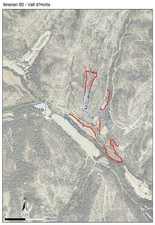
Sections
The map shows the transect route and the layout of the different sections. The background photograph corresponds to the 1:5000 orthophoto from the Cartographic Institute of Catalonia (ICGC).
Species occurring in this transect
Click to the Table to see the species list ordered by the abundance index average standardized at 100 m. Also, there is the trend each species follows in this itinerary. If you click the trend of any species you will enter Species by itinerary results. For more information about the index and trends calculation see Data analysis


Illustrations by Richard Lewington from Tolman & Lewington (1997) Butterflies of Britain and Europe, translated and published in Spanish by Lynx Edicions.
Change sheet
Characteristics
UTM10x10: 31T DG11
Province: Barcelona
County: Vallès Occidental
Municipality: Sant Llorenç Savall
Protected area: Sant Llorenç del Munt i l'Obac
Climatic region:
Mediterrani humit
Number of sections: 10
Total length: 2260 m
Average length: 226 m
Average altitude: 516 m
Participants: Q Muñoz
Sponsors: DIBA - PN Sant Llorenç del Munt i l'Obac 
Web map | Legal notes | Credits
Project in agreement with:


In collaboration with:

