Aquesta web utiliza cookies tècniques, de personalització i anàlisi, pròpies i de tercers, per facilitar-li la navegació de forma anònima i analitzar estadístiques de l'ús de la web.
Considerem que, si continua navegant, n'accepta el seu ús. Obtenir més informació
i
Muntanyesa de primavera (Erebia epistygne) - Jordi Corbera
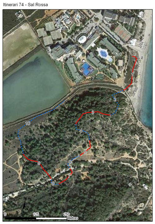
Itinerari situat al sud-est de l’illa d’Eivissa, al municipi de Sant Josep de sa Talaia. Consta de 10 seccions, una longitud de 1.379 metres i es troba a primera línia de costa, en una zona molt propera al mar. Els itineraris es van efectuar durant vuit anys, des del 2005 al 2012.
El recorregut passa per dunes, brolles, pinedes i diverses formacions de prats.
Sampling and data series
Years with data: 8 [2005-2012] Recorded species: 18 (Annual average: 10) Recorded individuals : 1910 (Annual average: 239) Number of recording samples: 200
Climatic variables
Average annual temperature: --- Average of January minima: --- Average of July maxima: --- Annual precipitation: ---
Phenology
The bars show the weekly average butterfly abundance (calculated as the number of specimens per 1000 m) for the set of species recorded in the transect. Dots correspond to the weekly average number of species.
Habitats
Without data vegetation. Botanical characterization has not been done yet.
Sections
The map shows the transect route and the layout of the different sections. The background photograph corresponds to the 1:5000 orthophoto from the Cartographic Institute of Catalonia (ICGC).
Species occurring in this transect
Click to the Table to see the species list ordered by the abundance index average standardized at 100 m. Also, there is the trend each species follows in this itinerary. If you click the trend of any species you will enter Species by itinerary results. For more information about the index and trends calculation see Data analysis