Aquesta web utiliza cookies tècniques, de personalització i anàlisi, pròpies i de tercers, per facilitar-li la navegació de forma anònima i analitzar estadístiques de l'ús de la web.
Considerem que, si continua navegant, n'accepta el seu ús. Obtenir més informació
i
Lleonada de garriga (Coenonympha dorus) - Pau Ortega i Colet
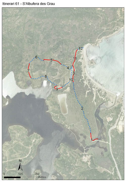
L'itinerari des Grau està situat al Parc Natural de s’Albufera des Grau, entre la llacuna principal i la platja homònima. Els mostratges es van iniciar el 2001, el primer any de l’aplicació del BMS a Menorca, i s'han mantingut ininterrompudament fins a l'actualitat. L'itinerari surt de zona coneguda com sa Gola, travessa el pinar de l’arenal des Grau, es desvia cap a l’interior pujant al coster d’en Truja i acaba a la platja. Té una longitud de 1.856 m i 12 seccions, amb una mitjana de 154,2 m per secció.
La zona se situa entre l’albufera i el sistema platja-duna, de manera que les comunitats vegetals predominants són les lligades a arenals i zones humides. Així i tot, la meitat del recorregut correspon a hàbitats forestals litorals com pinedes de pi blanc, savinars i brolles de bruc. Pràcticament en tot el recorregut és patent la influència de la llacuna i de les zones d’inundació temporal.
Les brolles corresponen a antigues zones de cultiu que a la darrera dècada han passat de camps abandonats a bruguerars més alts i espessos. Això està fent que la zona vagi perdent espècies d’espais oberts per guanyar-ne de forestals. No obstant, el principal canvi en abundància observat a l’itinerari és la disminució progressiva de Polyommatus celina per raons encara desconegudes.
Sampling and data series
Years with data: 25 [2001-2025] Recorded species: 23 (Annual average: 18) Recorded individuals : 27352 (Annual average: 1094) Number of recording samples: 689
Climatic variables
Average annual temperature: --- Average of January minima: --- Average of July maxima: --- Annual precipitation: ---
Phenology
The bars show the weekly average butterfly abundance (calculated as the number of specimens per 1000 m) for the set of species recorded in the transect. Dots correspond to the weekly average number of species.
Habitats
The graph shows the relative cover of each habitat type in the whole transect. Since 2000, a botanical characterization has been performed for each itinerary every six years. For itineraries with more than one botanical characterization, you can change from one to another by clicking on the year of characterization.
2022
2016
2010
2003
Sections
The map shows the transect route and the layout of the different sections. The background photograph corresponds to the 1:5000 orthophoto from the Cartographic Institute of Catalonia (ICGC).
Species occurring in this transect
Click to the Table to see the species list ordered by the abundance index average standardized at 100 m. Also, there is the trend each species follows in this itinerary. If you click the trend of any species you will enter Species by itinerary results. For more information about the index and trends calculation see Data analysis