Aquesta web utiliza cookies tècniques, de personalització i anàlisi, pròpies i de tercers, per facilitar-li la navegació de forma anònima i analitzar estadístiques de l'ús de la web.
Considerem que, si continua navegant, n'accepta el seu ús. Obtenir més informació
i
Griseta mediterrània (Lysandra hispana) - Pau Ortega i Colet
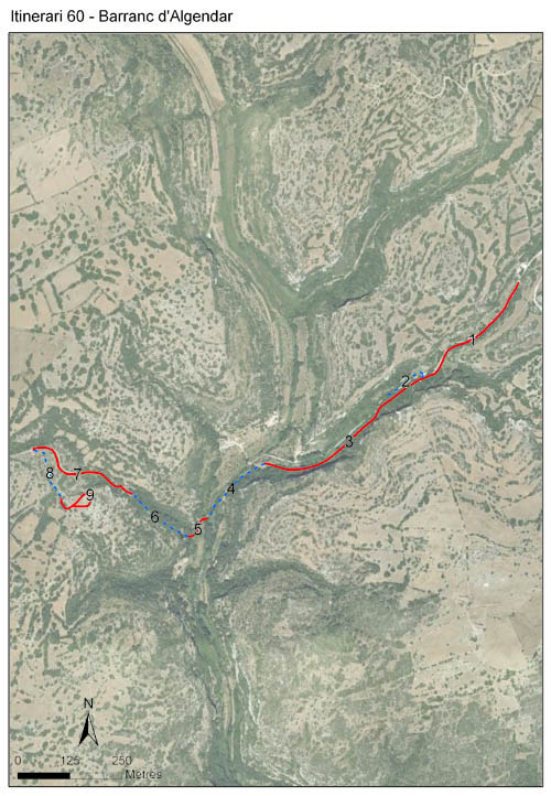
El barranc d’Algendar solca la plataforma calcària del sud de l’illa de Menorca de nord a sud, des del pla verd fins a desembocar a cala Galdana, essent la frontera natural entre els municipis de Ciutadella i Ferreries. El recorregut s’inicia al Canaló, en un dels ramals del barranc, continua fins a trobar la llera principal del barranc, i després torna a separar-se pujant per l’altre vessant. Té una longitud de 1.975 metres distribuïts en 9 seccions.
L’inici discorre per un camí vorejant el costat esquerre del barranc, on es troben majoritàriament parres, figueres i heura a la paret, i a l’altra banda del camí horts tradicionals de fruita. A continuació, el recorregut s’endinsa per un d’aquests horts fruiters continuant altre cop arran de paret. A partir d’aquest punt guanyen molta importància les bardisses. A l’encreuament amb el barranc principal, l’itinerari discorre al costat del curs d’aigua on es troba canyar i vegetació de torrent (cues de cavall, lliris, menta, bova, llorers). Després comença a pujar per un dels ramals del barranc i per dins d'un petit alzinar ombrívol. Més amunt comencen a desaparèixer les condicions d’humitat i frescor pròpies del fons i la vegetació va canviant gradualment cap a ullastrar i herbassars secs fins acabar en unes tanques pasturades.
L’espai té una marcada influència humana, i la seva gestió no ha patit canvis substancials des de l’inici del BMS l’any 2001 fins a l’actualitat. Bàsicament es centra en l’agricultura ecològica dels fruiters i en l’estassada periòdica dels esbarzers i arbustos de les parets seques que delimiten els horts i els camins. Cal dir que en el darrers anys s’han tornat a cultivar zones abandonades, i que s'han eliminat els arbusts i bardisses que les havien envaït. A la ribera del torrent també es fan estassades periòdiques per part d’un grup local de voluntaris, eliminant la vegetació de la ribera que torna a rebrotar al cap d’un temps. La resta de l’itinerari no té una gestió activa, fins arribar a la darrera secció que és pasturada per bens.
Les condicions microclimàtiques d’humitat i frescor del barranc fan que la comunitat de ropalòcers d’Algendar presenti un patró fenològic amb un màxim estival al voltant de la quarta setmana de juny, màxim que es troba endarrerit respecte d'altres estacions menorquines. A més, l’abundància d’individus es manté més elevada durant tot l’estiu i tardor.
Years with data: 25 [2001-2025] Recorded species: 23 (Annual average: 18) Recorded individuals : 58732 (Annual average: 2349) Number of recording samples: 699
Climatic variables
Average annual temperature: --- Average of January minima: --- Average of July maxima: --- Annual precipitation: ---
Phenology
The bars show the weekly average butterfly abundance (calculated as the number of specimens per 1000 m) for the set of species recorded in the transect. Dots correspond to the weekly average number of species.
Habitats
The graph shows the relative cover of each habitat type in the whole transect. Since 2000, a botanical characterization has been performed for each itinerary every six years. For itineraries with more than one botanical characterization, you can change from one to another by clicking on the year of characterization.
2022
2016
2010
2003
Sections
The map shows the transect route and the layout of the different sections. The background photograph corresponds to the 1:5000 orthophoto from the Cartographic Institute of Catalonia (ICGC).
Species occurring in this transect
Click to the Table to see the species list ordered by the abundance index average standardized at 100 m. Also, there is the trend each species follows in this itinerary. If you click the trend of any species you will enter Species by itinerary results. For more information about the index and trends calculation see Data analysis