Aquesta web utiliza cookies tècniques, de personalització i anàlisi, pròpies i de tercers, per facilitar-li la navegació de forma anònima i analitzar estadístiques de l'ús de la web.
Considerem que, si continua navegant, n'accepta el seu ús. Obtenir més informació
i
Vellutada del salze (Nymphalis antiopa) - Andreu Ubach
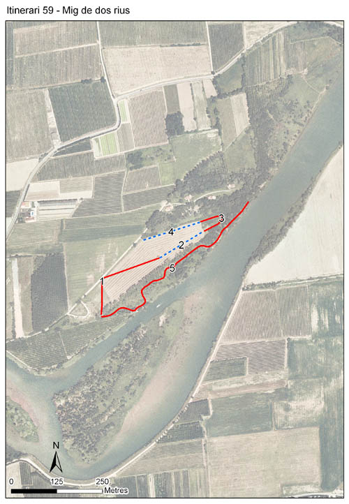
L’itinerari de Mig de Dos Rius està situat al tram final del riu Fluvià, dins del Parc Natural dels Aiguamolls de l'Empordà. El recorregut consta de 5 seccions, amb una distància total d’uns 1.266 m. S'han fet comptatges de papallones des de l'any 2002 al 2022, i l'any 2024 s'ha tornat a reprendre el transsecte.
El recorregut comença amb dues seccions en una closa, envoltada d’un bosc de pollancres, freixes i una franja de canyís i canya.El prat està gestionat amb pastura i dall i s'hi ha pogut apreciar una millora en la diversitat floral des del començament d'aquesta de gestió. També és on es troba la major densitat de papallones, especialment a la secció 1, on hi ha grans quantitats de Lotus corniculatus i altres lleguminoses.
El transsecte continua per la curta secció 3, que consta d’un bosc de freixes, aclarit fa poc a causa d'una excessiva densitat d'arbres petitst. La secció 4 inclou la vora del prat amb canyís i canya, i la 5 segueix un camí a la vora del riu Fluvià que travessa una pollancreda.
Durant l’agost i el setembre, s’inclouen comptatges en una sisena secció, mes enllà de la 5, on tendeix a concentrar-se la papallona tigre, Danaus chrysippus, quan hi arriba en onades migratòries. En aquesta zona hi creix molt abundant Cynanchum acutum, la planta nutrícia que utilitza la papallona tigre als Aiguamolls de l'Empordà.
Sampling and data series
Years with data: 23 [2002-2022,2024-2025] Recorded species: 40 (Annual average: 20) Recorded individuals : 16261 (Annual average: 707) Number of recording samples: 629
Climatic variables
Average annual temperature: 15 ºC Average of January minima: 4 ºC Average of July maxima: 28 ºC Annual precipitation: 616 mm
Phenology
The bars show the weekly average butterfly abundance (calculated as the number of specimens per 1000 m) for the set of species recorded in the transect. Dots correspond to the weekly average number of species.
Habitats
The graph shows the relative cover of each habitat type in the whole transect. Since 2000, a botanical characterization has been performed for each itinerary every six years. For itineraries with more than one botanical characterization, you can change from one to another by clicking on the year of characterization.
2020
2014
2008
2001
Sections
The map shows the transect route and the layout of the different sections. The background photograph corresponds to the 1:5000 orthophoto from the Cartographic Institute of Catalonia (ICGC).
Species occurring in this transect
Click to the Table to see the species list ordered by the abundance index average standardized at 100 m. Also, there is the trend each species follows in this itinerary. If you click the trend of any species you will enter Species by itinerary results. For more information about the index and trends calculation see Data analysis