55 - Campllong
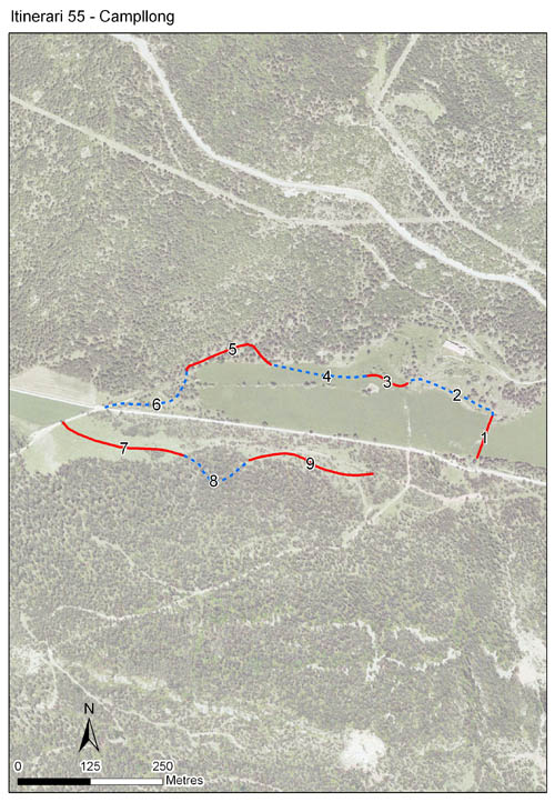
Situat als peus dels Rasos de Peguera, a la comarca del Berguedà, al municipi de Castellar del Riu, amb una alçada mitjana de 1.288 m. Els comptatges s’iniciaren l’any 2001 i s’ha mantingut fins a l'actualitat, amb l'excepció dels anys 2012 i 2018 en els que no es va poder fer el seguiment. El recorregut té 9 seccions, amb una longitud total de 1.426 m i una longitud mitjana de 158 m per secció.
L’itinerari transcorre en una zona de prats subalpins en un dels quals hi ha l'emblemàtic Pi de les Tres Branques. Prats on es desenvolupa activitat ramadera i que s’insereixen en un espai de pineda de pi roig. Es troba inscrit en l’espai protegit de la Serra de Queralt.


- Cynthia 5, page 12 El Pla de Campllong, un itinerari a la porta dels Pirineus
References to Cynthia magazine
Sampling and data series
Years with data: 23 [2001-2011,2013-2017,2019-2025] |
Climatic variables
Average annual temperature: 9 ºC |
Phenology
The bars show the weekly average butterfly abundance (calculated as the number of specimens per 1000 m) for the set of species recorded in the transect. Dots correspond to the weekly average number of species.
Habitats
The graph shows the relative cover of each habitat type in the whole transect. Since 2000, a botanical characterization has been performed for each itinerary every six years. For itineraries with more than one botanical characterization, you can change from one to another by clicking on the year of characterization.
Sections
The map shows the transect route and the layout of the different sections. The background photograph corresponds to the 1:5000 orthophoto from the Cartographic Institute of Catalonia (ICGC).
Species occurring in this transect
Click to the Table to see the species list ordered by the abundance index average standardized at 100 m. Also, there is the trend each species follows in this itinerary. If you click the trend of any species you will enter Species by itinerary results. For more information about the index and trends calculation see Data analysis


Illustrations by Richard Lewington from Tolman & Lewington (1997) Butterflies of Britain and Europe, translated and published in Spanish by Lynx Edicions.
Change sheet
Characteristics
UTM10x10: 31T CG96
Province: Barcelona
County: Berguedà
Municipality: Castellar del Riu
Protected area: Serra de Queralt
Climatic region:
Alpí i subalpí
Number of sections: 9
Total length: 1426 m
Average length: 158 m
Average altitude: 1289 m
Participants: E Escútia
Web map | Legal notes | Credits
Project in agreement with:


In collaboration with:

