Aquesta web utiliza cookies tècniques, de personalització i anàlisi, pròpies i de tercers, per facilitar-li la navegació de forma anònima i analitzar estadístiques de l'ús de la web.
Considerem que, si continua navegant, n'accepta el seu ús. Obtenir més informació
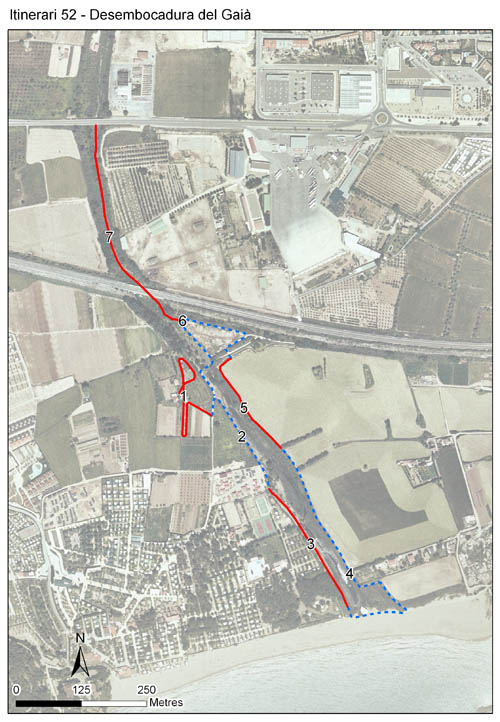
Localitzat a Tarragona, en el tram final del riu Gaià, que s’insereix en l’espai protegit que conforma la Desembocadura del riu Gaià. L’itinerari comença a primera línia de costa i amb una alçada mitjana de 5 m transcorre 7 seccions amb una longitud total de 2.476 metres. Es va iniciar l’any 2001, i després d’una parada l’any 2002 es va reprendre el 2003, mantenint-se en funcionament fins a l’actualitat.
Es troba en una zona dominada per vegetació bàsicament ruderal, amb alguns trams de zona humida i bosc de ribera que acompanyen el Gaià, i altres formacions vegetals també presents a l’itinerari.
Sampling and data series
Years with data: 24 [2001,2003-2025] Recorded species: 33 (Annual average: 19) Recorded individuals : 26732 (Annual average: 1114) Number of recording samples: 678
Climatic variables
Average annual temperature: 16 ºC Average of January minima: 5 ºC Average of July maxima: 30 ºC Annual precipitation: 549 mm
Phenology
The bars show the weekly average butterfly abundance (calculated as the number of specimens per 1000 m) for the set of species recorded in the transect. Dots correspond to the weekly average number of species.
Habitats
The graph shows the relative cover of each habitat type in the whole transect. Since 2000, a botanical characterization has been performed for each itinerary every six years. For itineraries with more than one botanical characterization, you can change from one to another by clicking on the year of characterization.
2025
2019
2013
2007
2000
Sections
The map shows the transect route and the layout of the different sections. The background photograph corresponds to the 1:5000 orthophoto from the Cartographic Institute of Catalonia (ICGC).
Species occurring in this transect
Click to the Table to see the species list ordered by the abundance index average standardized at 100 m. Also, there is the trend each species follows in this itinerary. If you click the trend of any species you will enter Species by itinerary results. For more information about the index and trends calculation see Data analysis