5 - Darnius
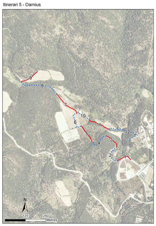
L’itinerari de Darnius es troba als afores del nucli urbà del mateix nom, al peu del massis de les Salines i vora el riu Ricardell, a l’Alt Empordà. Els comptatges es van iniciar el 1994, el primer any del CBMS, i s’han mantingut ininterrompudament fins l’actualitat. L’itinerari té una longitud de 1.695 m i 12 seccions, amb una mitjana de 141,3 m per secció.
Recull dades d’un ambient típicament mediterrani, dominat per l’alzinar i la sureda, però també amb una bona representació de fenassars i llistonars, a més d’altres ambients forestals i rurals. La diversitat d’ambients representats i el fet d’estar proper al massis de les Salines i la serra de l’Albera fa que la fauna de papallones sigui força diversa. Destaca l’excepcional abundància de diferents espècies de satirins.


- Cynthia 4, page 12 Darnius, una estació al cor del país de la tramuntana
References to Cynthia magazine
Sampling and data series
Years with data: 32 [1994-2025] |
Climatic variables
Average annual temperature: 14 ºC |
Phenology
The bars show the weekly average butterfly abundance (calculated as the number of specimens per 1000 m) for the set of species recorded in the transect. Dots correspond to the weekly average number of species.
Habitats
The graph shows the relative cover of each habitat type in the whole transect. Since 2000, a botanical characterization has been performed for each itinerary every six years. For itineraries with more than one botanical characterization, you can change from one to another by clicking on the year of characterization.
Sections
The map shows the transect route and the layout of the different sections. The background photograph corresponds to the 1:5000 orthophoto from the Cartographic Institute of Catalonia (ICGC).
Species occurring in this transect
Click to the Table to see the species list ordered by the abundance index average standardized at 100 m. Also, there is the trend each species follows in this itinerary. If you click the trend of any species you will enter Species by itinerary results. For more information about the index and trends calculation see Data analysis


Illustrations by Richard Lewington from Tolman & Lewington (1997) Butterflies of Britain and Europe, translated and published in Spanish by Lynx Edicions.
Change sheet
Characteristics
UTM10x10: 31T DG89
Province: Girona
County: Alt Empordà
Municipality: Darnius
Climatic region:
Mediterrani humit
Number of sections: 12
Total length: 1695 m
Average length: 141 m
Average altitude: 175 m
Participants: A Batlle
Web map | Legal notes | Credits
Project in agreement with:


In collaboration with:

