Aquesta web utiliza cookies tècniques, de personalització i anàlisi, pròpies i de tercers, per facilitar-li la navegació de forma anònima i analitzar estadístiques de l'ús de la web.
Considerem que, si continua navegant, n'accepta el seu ús. Obtenir més informació
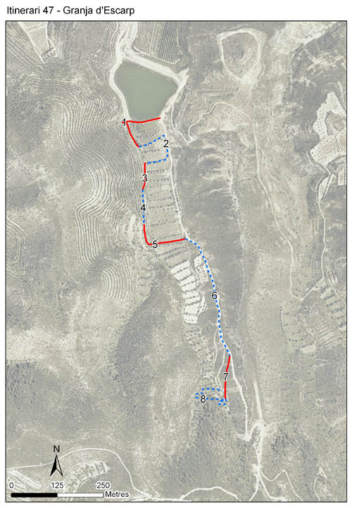
Ubicat al municipi de Granja d’Escarp, al Segrià, a una alçada de 247,9 m. Va funcionar des de l’any 2001 fins l’any 2008 i va ser recupera l’any 2017 com a itinerari de baix esforç, mantenint-se actiu fins el 2020. Consta de 8 seccions, amb 1.419 m de longitud total i per tant una longitud mitjana per secció de 177.
Es troba en una zona molt àrida de brolles, matollars dominats per siscallars, botja pudenta, etc. També llistonars i altres formacions vegetals. Es troba en una zona on hi ha presència d’espècies pròpies de zones àrides, escasses a Catalunya. S’hi ha citat la marbrada de ponent (Euchloe tagis), l’aurora dels guarets (Zegris eupheme) o l’escac ferruginós (Melanargia occitanica) entre d’altres.
Sampling and data series
Years with data: 13 [2001-2008,2010,2017-2020] Recorded species: 52 (Annual average: 23) Recorded individuals : 11188 (Annual average: 861) Number of recording samples: 266
Climatic variables
Average annual temperature: 14 ºC Average of January minima: 1 ºC Average of July maxima: 32 ºC Annual precipitation: 417 mm
Phenology
The bars show the weekly average butterfly abundance (calculated as the number of specimens per 1000 m) for the set of species recorded in the transect. Dots correspond to the weekly average number of species.
Habitats
The graph shows the relative cover of each habitat type in the whole transect. Since 2000, a botanical characterization has been performed for each itinerary every six years. For itineraries with more than one botanical characterization, you can change from one to another by clicking on the year of characterization.
2017
2006
2000
Sections
The map shows the transect route and the layout of the different sections. The background photograph corresponds to the 1:5000 orthophoto from the Cartographic Institute of Catalonia (ICGC).
Species occurring in this transect
Click to the Table to see the species list ordered by the abundance index average standardized at 100 m. Also, there is the trend each species follows in this itinerary. If you click the trend of any species you will enter Species by itinerary results. For more information about the index and trends calculation see Data analysis