28 - Pla de la Calma
Itinerari situat al Parc Natural del Monyseny. Consta de 13 seccions i una longitud total de 1.714 metres, amb una alçada mitjana de 1.193 metres. Es realitza ininterrompudament des de l'any 1997.
Situat a la part culminal del cantó oest del massís, que conforma una plana a uns mil metres d'altitud, es troba entre les comarques d'Osona i el Vallès Oriental i està constituït per prats montans que han patit diferents canvis al llarg del temps, com la transformació en zones de conreu i el tancament de l'hàbitat. Actualment també hi conté zones d'alzinar.


- Cynthia 2, page 10 Pla de la Calma, estació de gran riquesa lepidopteriològica
References to Cynthia magazine
Sampling and data series
Years with data: 29 [1997-2025] |
Climatic variables
Average annual temperature: 9 ºC |
Phenology
The bars show the weekly average butterfly abundance (calculated as the number of specimens per 1000 m) for the set of species recorded in the transect. Dots correspond to the weekly average number of species.
Habitats
The graph shows the relative cover of each habitat type in the whole transect. Since 2000, a botanical characterization has been performed for each itinerary every six years. For itineraries with more than one botanical characterization, you can change from one to another by clicking on the year of characterization.
Sections
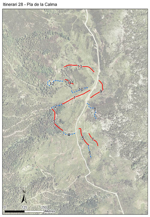
The map shows the transect route and the layout of the different sections. The background photograph corresponds to the 1:5000 orthophoto from the Cartographic Institute of Catalonia (ICGC).
Species occurring in this transect
Click to the Table to see the species list ordered by the abundance index average standardized at 100 m. Also, there is the trend each species follows in this itinerary. If you click the trend of any species you will enter Species by itinerary results. For more information about the index and trends calculation see Data analysis


Illustrations by Richard Lewington from Tolman & Lewington (1997) Butterflies of Britain and Europe, translated and published in Spanish by Lynx Edicions.
Change sheet
Characteristics
UTM10x10: 31T DG42
Province: Barcelona
County: Osona, Vallès Oriental
Municipality: el Brull, Tagamanent
Protected area: Massís del Montseny
Climatic region:
Alpí i subalpí
Number of sections: 13
Total length: 1714 m
Average length: 131 m
Average altitude: 1193 m
Participants: N Figueres, J Jubany
Sponsors: DIBA - PN Montseny 
Web map | Legal notes | Credits
Project in agreement with:


In collaboration with:

