Aquesta web utiliza cookies tècniques, de personalització i anàlisi, pròpies i de tercers, per facilitar-li la navegació de forma anònima i analitzar estadístiques de l'ús de la web.
Considerem que, si continua navegant, n'accepta el seu ús. Obtenir més informació
i
Vellutada del salze (Nymphalis antiopa) - Andreu Ubach
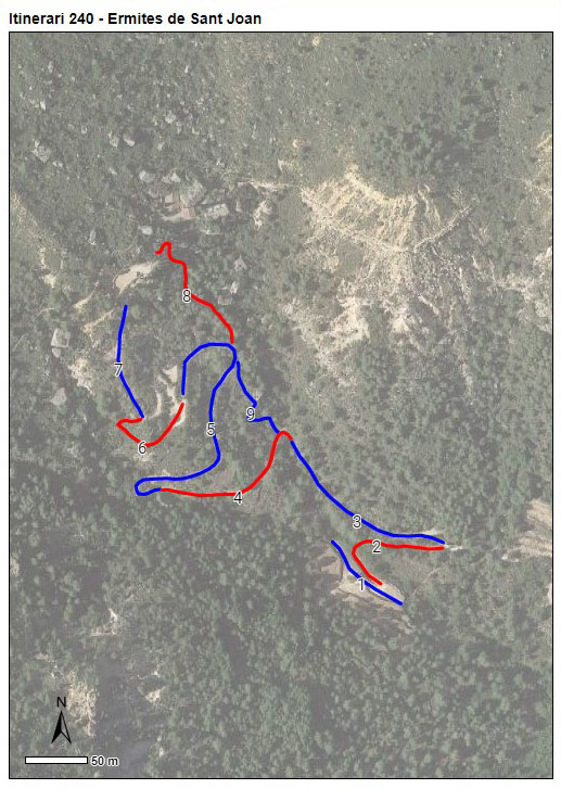
Itinerari situat a Cornudella de Montsant, a la comarca del Priorat, a l'espai protegit de la Serra del Montsant. A una alçada mitjana de 704 metres, té una llargada de 1.163 metres dividits en 9 seccions. S'hi recullen dades des de l'any 2023.
L’itinerari comença en una vinya de recent plantació i continua per una pista boscosa que travessa el barranc de Sant Joan fins a l’Ermita de Sant Joan Petit. Segueixen tres seccions que transcorren pel camí encimentat que puja a Sant Joan seguint el barranc, cadascuna menys boscosa que l'anterior. La següent secció transcorre per un camí envoltat de brucs, farigoles i romaní, una altra per un camí encimentat totalment obert fins a arribar a l’ermita de Sant Joan, i les dues últimes seccions recorren un corriol, amb un primer tram mes boscós i el segon mes obert fins el final del trassecte. La vegetació dominant és la típica del bosc de muntanya mitjana, amb presència tota l’estona del barranc de Sant Joan i el Montsant.
Sampling and data series
Years with data: 3 [2023-2025] Recorded species: 75 (Annual average: 58) Recorded individuals : 3567 (Annual average: 1189) Number of recording samples: 65
Climatic variables
Average annual temperature: 12 ºC Average of January minima: 1 ºC Average of July maxima: 27 ºC Annual precipitation: 630 mm
Phenology
The bars show the weekly average butterfly abundance (calculated as the number of specimens per 1000 m) for the set of species recorded in the transect. Dots correspond to the weekly average number of species.
Habitats
The graph shows the relative cover of each habitat type in the whole transect. Since 2000, a botanical characterization has been performed for each itinerary every six years. For itineraries with more than one botanical characterization, you can change from one to another by clicking on the year of characterization.
2024
Sections
The map shows the transect route and the layout of the different sections. The background photograph corresponds to the 1:5000 orthophoto from the Cartographic Institute of Catalonia (ICGC).
Species occurring in this transect
Click to the Table to see the species list ordered by the abundance index average standardized at 100 m. Also, there is the trend each species follows in this itinerary. If you click the trend of any species you will enter Species by itinerary results. For more information about the index and trends calculation see Data analysis