239 - Riera de Sant Cugat
Itinerari situat al municipi de Sant Cugat del Vallès, a la comarca del Vallès Occidental. Amb una longitud de 2.931 metres, consta d'11 seccions i està situat a una alçada mitjana de 93 metres. Es va incorporar a la xarxa del CBMS l'any 2023. L'any 2025 la zona va entrar en un procés d'obres que n'han impedit continuar els seguiments.
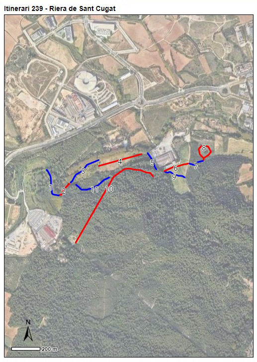
L'itinerari recorre per la vora gran part de la riera de Sant Cugat, de la que pren el nom. Comença en un camí que travessa una pollancreda amb clarianes fins arribar a una bifurcació on es passa a la secció 2, de caire similar però una mica més tancada, arribant a la riera.
Read more ...

Sampling and data series
Years with data: 3 [2023-2025] |
Climatic variables
Average annual temperature: 15 ºC |
Phenology
The bars show the weekly average butterfly abundance (calculated as the number of specimens per 1000 m) for the set of species recorded in the transect. Dots correspond to the weekly average number of species.
Habitats
The graph shows the relative cover of each habitat type in the whole transect. Since 2000, a botanical characterization has been performed for each itinerary every six years. For itineraries with more than one botanical characterization, you can change from one to another by clicking on the year of characterization.
Sections
The map shows the transect route and the layout of the different sections. The background photograph corresponds to the 1:5000 orthophoto from the Cartographic Institute of Catalonia (ICGC).
Species occurring in this transect
Click to the Table to see the species list ordered by the abundance index average standardized at 100 m. Also, there is the trend each species follows in this itinerary. If you click the trend of any species you will enter Species by itinerary results. For more information about the index and trends calculation see Data analysis


Illustrations by Richard Lewington from Tolman & Lewington (1997) Butterflies of Britain and Europe, translated and published in Spanish by Lynx Edicions.
Change sheet
Characteristics
UTM10x10: 31T DF29
Province: Barcelona
County: Vallès Occidental
Municipality: Cerdanyola del Vallès
Protected area: Serra de Collserola
Climatic region:
Mediterrani àrid
Number of sections: 11
Total length: 2931 m
Average length: 266 m
Average altitude: 93 m
Participants: C Pla-Narbona, M Alba
Web map | Legal notes | Credits
Project in agreement with:


In collaboration with:

