229 - Senyús
Itinerari situat al municipi de Cabó, a la comarca de l'Alt Urgell, a una alçada mitjana de 1.130 metres. Consta de 10 seccions amb una llargada total de 951 metres. Es va donar d'alta a la xarxa del CBMS l'any 2023.
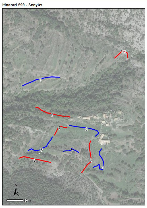
El transsecte recorre camps i feixes de Senyús, un poblet abandonat al 1970. Abans els camps eren de conreus de secà, ara són utilitzats com a terrenys de pastura per vaques (d’abril a juny, i a l’octubre). Les seccions 1-8 estan situades al nord de barranc de Senyús, a l'obaga, mentre que les seccions 9 i 10 són al sud, a la solana, en una zona anomenada La Devesa. Les seccions 1, 2, 4-8 i 10 estan dins de la micro-reserva de papallones de la Vall de Cabó. El sòl és calcari.
Read more ...


Sampling and data series
Years with data: 3 [2023-2025] |
Climatic variables
Average annual temperature: 9 ºC |
Phenology
The bars show the weekly average butterfly abundance (calculated as the number of specimens per 1000 m) for the set of species recorded in the transect. Dots correspond to the weekly average number of species.
Habitats
The graph shows the relative cover of each habitat type in the whole transect. Since 2000, a botanical characterization has been performed for each itinerary every six years. For itineraries with more than one botanical characterization, you can change from one to another by clicking on the year of characterization.
Sections
The map shows the transect route and the layout of the different sections. The background photograph corresponds to the 1:5000 orthophoto from the Cartographic Institute of Catalonia (ICGC).
Species occurring in this transect
Click to the Table to see the species list ordered by the abundance index average standardized at 100 m. Also, there is the trend each species follows in this itinerary. If you click the trend of any species you will enter Species by itinerary results. For more information about the index and trends calculation see Data analysis


Illustrations by Richard Lewington from Tolman & Lewington (1997) Butterflies of Britain and Europe, translated and published in Spanish by Lynx Edicions.
Change sheet
Characteristics
UTM10x10: 31T CG57
Province: Lleida
County: Alt Urgell
Municipality: Cabó
Climatic region:
Alpí i subalpí
Number of sections: 10
Total length: 951 m
Average length: 95 m
Average altitude: 1130 m
Participants: P Roy, J Lawbuary
Web map | Legal notes | Credits
Project in agreement with:


In collaboration with:

