219 - La Tossa de Montbui
Aquest itinerari està situat al municipi de Santa Margarida de Montbui, comarca de l'Anoiaa, dins de l'Espai d'Interès Natural de Santa Maria de Miralles - Queralt, . Amb una llargada de 1.113 metres i una altitud mitjana de 616 metres, consta de 8 seccions i es mostreja des de l'any 2022.
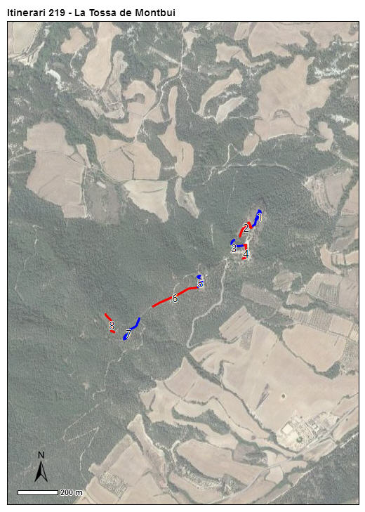
A la secció 1 hi trobem la primera de tres zones de "hilltopping" que tenim en aquest transsecte, que discorre carenejant des del punt elevat més septentrional de la Serra de Miralles. Una petita clariana amb vistes al voltant de la creu que la culmina, a la que accedim entre pins, alzines i vegetació herbàcia baixa per un camí carener. El transsecte segueix per sota del turó, passant per un camí molt assolellat amb herba baixa als costats. La secció 3 torna a pujar cap amunt per un camí tancat força ombrívol. La quarta secció passa pel costat d'una zona enjardinada a sota d'una antiga església, de les runes d'un castell i un restaurant, una zona a solell des de on podem tornar a gaudir de nou de papiliònids i satirins competint pel territori.
Read more ...

Sampling and data series
Years with data: 4 [2022-2025] |
Climatic variables
Average annual temperature: 13 ºC |
Phenology
The bars show the weekly average butterfly abundance (calculated as the number of specimens per 1000 m) for the set of species recorded in the transect. Dots correspond to the weekly average number of species.
Habitats
The graph shows the relative cover of each habitat type in the whole transect. Since 2000, a botanical characterization has been performed for each itinerary every six years. For itineraries with more than one botanical characterization, you can change from one to another by clicking on the year of characterization.
Sections
The map shows the transect route and the layout of the different sections. The background photograph corresponds to the 1:5000 orthophoto from the Cartographic Institute of Catalonia (ICGC).
Species occurring in this transect
Click to the Table to see the species list ordered by the abundance index average standardized at 100 m. Also, there is the trend each species follows in this itinerary. If you click the trend of any species you will enter Species by itinerary results. For more information about the index and trends calculation see Data analysis


Illustrations by Richard Lewington from Tolman & Lewington (1997) Butterflies of Britain and Europe, translated and published in Spanish by Lynx Edicions.
Change sheet
Characteristics
UTM10x10: 31T CG80
Province: Barcelona
County: Anoia
Municipality: Santa Margarida de Montbui
Protected area: Serra de Miralles-Queralt
Climatic region:
Mediterrani humit
Number of sections: 8
Total length: 1123 m
Average length: 140 m
Average altitude: 616 m
Participants: I Abad
Web map | Legal notes | Credits
Project in agreement with:


In collaboration with:

