Aquesta web utiliza cookies tècniques, de personalització i anàlisi, pròpies i de tercers, per facilitar-li la navegació de forma anònima i analitzar estadístiques de l'ús de la web.
Considerem que, si continua navegant, n'accepta el seu ús. Obtenir més informació
i
Migradora dels cards (Vanessa cardui) - Jordi Corbera
Itinerari situat al terme municipal de Gandesa, al bell mig de la comarca vitícola de la Terra Alta. Té una longitud total de 1.282 metres, consta d'11 seccions, i es troba a una alçada mitjana de 418 metres sobre el nivell del mar. Els mostreigs es van iniciar el 2021.
El transsecte recorre diferents ambients entre els quals hi trobem vinyes, marges de pedra seca, brolles, pinars i carrascars, i es duu a terme a l'Herència Altés, situada a la finca de Lo Grau de l’Inquisidor, a la falda del jaciment arqueològic del Coll del Moro i a tocar del Massís del Port, que dona nom a un projecte de viticultura ecològica emmarcat dintre de la Denominació d’Origen Terra Alta.
Sampling and data series
Years with data: 5 [2021-2025] Recorded species: 45 (Annual average: 27) Recorded individuals : 2131 (Annual average: 426) Number of recording samples: 130
Climatic variables
Average annual temperature: 14 ºC Average of January minima: 2 ºC Average of July maxima: 30 ºC Annual precipitation: 518 mm
Phenology
The bars show the weekly average butterfly abundance (calculated as the number of specimens per 1000 m) for the set of species recorded in the transect. Dots correspond to the weekly average number of species.
Habitats
The graph shows the relative cover of each habitat type in the whole transect. Since 2000, a botanical characterization has been performed for each itinerary every six years. For itineraries with more than one botanical characterization, you can change from one to another by clicking on the year of characterization.
2022
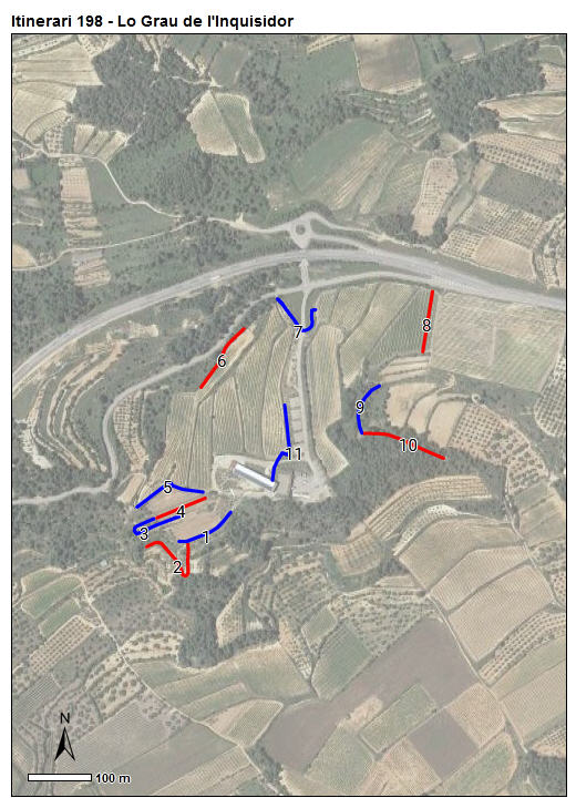
Sections
The map shows the transect route and the layout of the different sections. The background photograph corresponds to the 1:5000 orthophoto from the Cartographic Institute of Catalonia (ICGC).
Species occurring in this transect
Click to the Table to see the species list ordered by the abundance index average standardized at 100 m. Also, there is the trend each species follows in this itinerary. If you click the trend of any species you will enter Species by itinerary results. For more information about the index and trends calculation see Data analysis