Aquesta web utiliza cookies tècniques, de personalització i anàlisi, pròpies i de tercers, per facilitar-li la navegació de forma anònima i analitzar estadístiques de l'ús de la web.
Considerem que, si continua navegant, n'accepta el seu ús. Obtenir més informació
i
Lleonada de matollar (Coenonympha arcania) - Pau Ortega i Colet
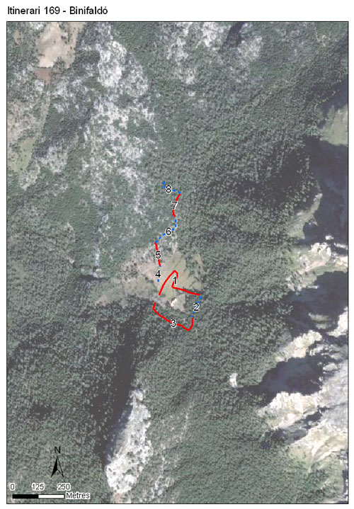
L'itinerari de Binifaldó rep el nom d'una finca pública situada al centre de la Serra de Tramuntana a més de 500 metres d'altitud. Aquest itinerari va estar en funcionament des de l'any 2019 al 2024 i consta de 8 seccions amb una longitud total de 1.375 metres.
La vegetació predominant de la zona es el bosc d'alzinar, en part, gràcies a l'abundància d'aigua en aquest indret de la Serra. Tanmateix, l'itinerari transcorre zones que varen ser desforestades per prevenció d'incendis forestals. La vegetació substitutiva fou xiprell, romaní i mata. No obstant, la vegetació dominant de les zones obertes són les estepes que varen actuar com espècies pioneres i cobreixen bona part de la cobertura arbustiva.
Sampling and data series
Years with data: 7 [2019-2025] Recorded species: 20 (Annual average: 14) Recorded individuals : 2044 (Annual average: 341) Number of recording samples: 106
Climatic variables
Average annual temperature: --- Average of January minima: --- Average of July maxima: --- Annual precipitation: ---
Phenology
The bars show the weekly average butterfly abundance (calculated as the number of specimens per 1000 m) for the set of species recorded in the transect. Dots correspond to the weekly average number of species.
Habitats
The graph shows the relative cover of each habitat type in the whole transect. Since 2000, a botanical characterization has been performed for each itinerary every six years. For itineraries with more than one botanical characterization, you can change from one to another by clicking on the year of characterization.
2021
Sections
The map shows the transect route and the layout of the different sections. The background photograph corresponds to the 1:5000 orthophoto from the Cartographic Institute of Catalonia (ICGC).
Species occurring in this transect
Click to the Table to see the species list ordered by the abundance index average standardized at 100 m. Also, there is the trend each species follows in this itinerary. If you click the trend of any species you will enter Species by itinerary results. For more information about the index and trends calculation see Data analysis