Aquesta web utiliza cookies tècniques, de personalització i anàlisi, pròpies i de tercers, per facilitar-li la navegació de forma anònima i analitzar estadístiques de l'ús de la web.
Considerem que, si continua navegant, n'accepta el seu ús. Obtenir més informació
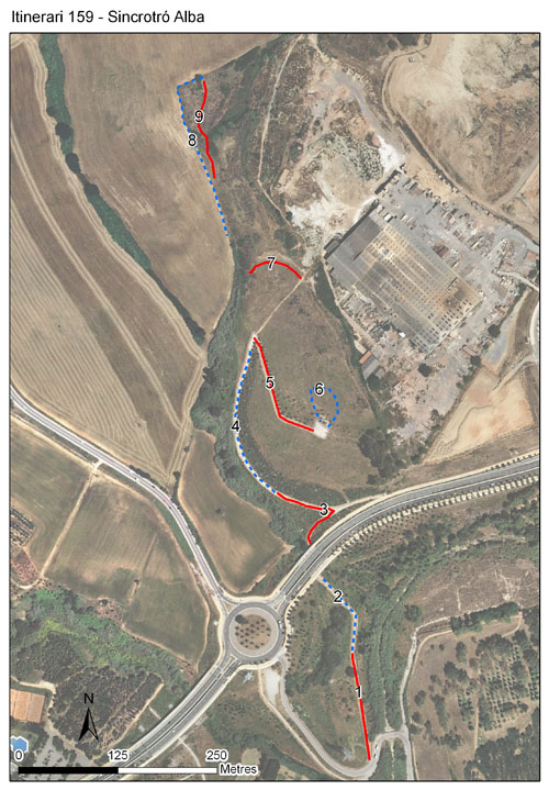
Itinerari de baix esforç situat a la zona agrícola del Parc de l’Alba, en el marc del projecte de seguiment de biodiversitat que s’ha establert en aquesta zona de Cerdanyola del Vallès. Té una longitud de 1.293 metres i 9 seccions, amb una alçada mitjana de 109 metres. Es va mostrejar del 2018 al 2020, recuperant-se l'any 2023.
Està situat a la terra baixa mediterrània amb una presència dominant d’ambients ruderals, combinats amb matollars i prats mediterranis, i immers en una zona de conreus herbacis.
Sampling and data series
Years with data: 6 [2018-2020,2023-2025] Recorded species: 48 (Annual average: 29) Recorded individuals : 4403 (Annual average: 734) Number of recording samples: 87
Climatic variables
Average annual temperature: 15 ºC Average of January minima: 3 ºC Average of July maxima: 30 ºC Annual precipitation: 564 mm
Phenology
The bars show the weekly average butterfly abundance (calculated as the number of specimens per 1000 m) for the set of species recorded in the transect. Dots correspond to the weekly average number of species.
Habitats
The graph shows the relative cover of each habitat type in the whole transect. Since 2000, a botanical characterization has been performed for each itinerary every six years. For itineraries with more than one botanical characterization, you can change from one to another by clicking on the year of characterization.
2018
Sections
The map shows the transect route and the layout of the different sections. The background photograph corresponds to the 1:5000 orthophoto from the Cartographic Institute of Catalonia (ICGC).
Species occurring in this transect
Click to the Table to see the species list ordered by the abundance index average standardized at 100 m. Also, there is the trend each species follows in this itinerary. If you click the trend of any species you will enter Species by itinerary results. For more information about the index and trends calculation see Data analysis