158 - Sant Miquel del Fai
Itinerari de baix esforç situat al municipi de Sant Quirze Safaja, a la finca de la Diputació de Barcelona on conflueixen el riu Rossinyol i el Fai, a la zona de l’espai protegit dels Cingles de Bertí. Amb una longitud total de 1.147 metres i a una alçada de 544 metres, es divideix en 8 seccions. L’itinerari s’efectua des del 2018.
Es conforma per ambients de muntanya baixa mediterrània de la serralada prelitoral. El recorregut incorpora codines, zones de matoll amb lligabosc, farigola i romaní, i màquies amb abundant arboç.

Sampling and data series
Years with data: 8 [2018-2025] |
Climatic variables
Average annual temperature: 13 ºC |
Phenology
The bars show the weekly average butterfly abundance (calculated as the number of specimens per 1000 m) for the set of species recorded in the transect. Dots correspond to the weekly average number of species.
Habitats
The graph shows the relative cover of each habitat type in the whole transect. Since 2000, a botanical characterization has been performed for each itinerary every six years. For itineraries with more than one botanical characterization, you can change from one to another by clicking on the year of characterization.
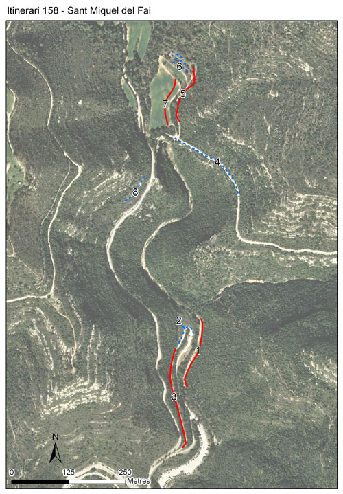
Sections
The map shows the transect route and the layout of the different sections. The background photograph corresponds to the 1:5000 orthophoto from the Cartographic Institute of Catalonia (ICGC).
Species occurring in this transect
Click to the Table to see the species list ordered by the abundance index average standardized at 100 m. Also, there is the trend each species follows in this itinerary. If you click the trend of any species you will enter Species by itinerary results. For more information about the index and trends calculation see Data analysis


Illustrations by Richard Lewington from Tolman & Lewington (1997) Butterflies of Britain and Europe, translated and published in Spanish by Lynx Edicions.
Change sheet
Characteristics
UTM10x10: 31T DG31
Province: Barcelona
County: Moianès
Municipality: Sant Quirze Safaja
Protected area: Cingles de Bertí
Climatic region:
Mediterrani humit
Number of sections: 8
Total length: 1147 m
Average length: 143 m
Average altitude: 544 m
Participants: A Ubach
Sponsors: Diputació de Barcelona (2018), Museu de Ciències Naturals de Granollers 
Web map | Legal notes | Credits
Project in agreement with:


In collaboration with:

