Aquesta web utiliza cookies tècniques, de personalització i anàlisi, pròpies i de tercers, per facilitar-li la navegació de forma anònima i analitzar estadístiques de l'ús de la web.
Considerem que, si continua navegant, n'accepta el seu ús. Obtenir més informació
i
Bruixa petita (Chazara briseis) - Pau Ortega i Colet
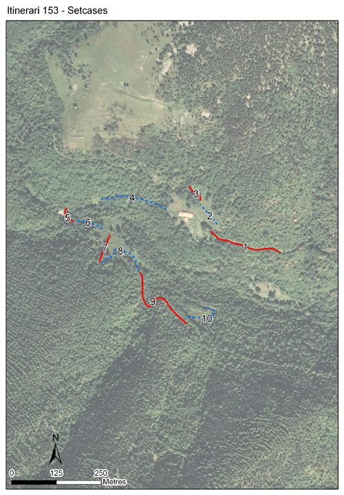
Itinerari situat a 1.434 metres d’alçada, té una longitud total de 1.258 metres i 10 seccions. Discorre pel fons de la vall de la finca del Catllar, que es troba dins l'Espai protegit de les Capçaleres del Ter i del Freser. Es realitza des de l’any 2017.
Incorpora diferents prats de pastura, petits prats de dall mig tancats per l'abandonament i també bosc de ribera. El microclima d'aquesta vall és extremament humit, de manera que algunes espècies centreeuropees associades a climes plujosos hi són molt abundants.
Sampling and data series
Years with data: 9 [2017-2025] Recorded species: 86 (Annual average: 53) Recorded individuals : 7723 (Annual average: 858) Number of recording samples: 124
Climatic variables
Average annual temperature: 8 ºC Average of January minima: -2 ºC Average of July maxima: 21 ºC Annual precipitation: 1122 mm
Phenology
The bars show the weekly average butterfly abundance (calculated as the number of specimens per 1000 m) for the set of species recorded in the transect. Dots correspond to the weekly average number of species.
Habitats
The graph shows the relative cover of each habitat type in the whole transect. Since 2000, a botanical characterization has been performed for each itinerary every six years. For itineraries with more than one botanical characterization, you can change from one to another by clicking on the year of characterization.
2023
2018
Sections
The map shows the transect route and the layout of the different sections. The background photograph corresponds to the 1:5000 orthophoto from the Cartographic Institute of Catalonia (ICGC).
Species occurring in this transect
Click to the Table to see the species list ordered by the abundance index average standardized at 100 m. Also, there is the trend each species follows in this itinerary. If you click the trend of any species you will enter Species by itinerary results. For more information about the index and trends calculation see Data analysis
UTM10x10: 31T DG39, DG49 Province: Girona County: Ripollès Municipality: Vilallonga de Ter Protected area: Capçaleres del Ter i del Freser Climatic region: Alpí i subalpí
Number of sections: 10 Total length: 1258 m Average length: 125 m Average altitude: 1434 m