Aquesta web utiliza cookies tècniques, de personalització i anàlisi, pròpies i de tercers, per facilitar-li la navegació de forma anònima i analitzar estadístiques de l'ús de la web.
Considerem que, si continua navegant, n'accepta el seu ús. Obtenir més informació
i
Vellutada del salze (Nymphalis antiopa) - Andreu Ubach
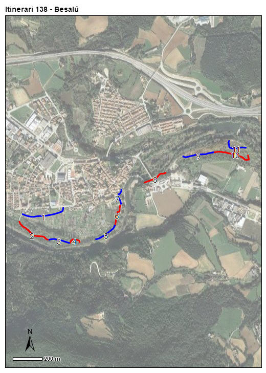
Itinerari de 2.059 metres de longitud total dividits en 11 seccions, que discorre pels voltants de Besalú i del riu Fluvià, a la Garrotxa. Amb una alçada mitjana de 137 metres, es van efectuar els comptatges entre els anys 2015 i 2021.
Es tracta d’un ambient en general molt alterat. Les comunitats vegetals ruderals predominen en bona part de l'itinerari, però també apareixen altres comunitats molt relacionades amb l'activitat humana, com ara plantacions de plàtans i parcs urbans.
Sampling and data series
Years with data: 7 [2015-2021] Recorded species: 67 (Annual average: 50) Recorded individuals : 7201 (Annual average: 1029) Number of recording samples: 185
Climatic variables
Average annual temperature: 14 ºC Average of January minima: 1 ºC Average of July maxima: 29 ºC Annual precipitation: 874 mm
Phenology
The bars show the weekly average butterfly abundance (calculated as the number of specimens per 1000 m) for the set of species recorded in the transect. Dots correspond to the weekly average number of species.
Habitats
The graph shows the relative cover of each habitat type in the whole transect. Since 2000, a botanical characterization has been performed for each itinerary every six years. For itineraries with more than one botanical characterization, you can change from one to another by clicking on the year of characterization.
2022
2016
Sections
The map shows the transect route and the layout of the different sections. The background photograph corresponds to the 1:5000 orthophoto from the Cartographic Institute of Catalonia (ICGC).
Species occurring in this transect
Click to the Table to see the species list ordered by the abundance index average standardized at 100 m. Also, there is the trend each species follows in this itinerary. If you click the trend of any species you will enter Species by itinerary results. For more information about the index and trends calculation see Data analysis