Aquesta web utiliza cookies tècniques, de personalització i anàlisi, pròpies i de tercers, per facilitar-li la navegació de forma anònima i analitzar estadístiques de l'ús de la web.
Considerem que, si continua navegant, n'accepta el seu ús. Obtenir més informació
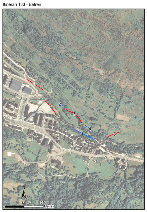
L’itinerari de Betren es troba als afores del poble del mateix nom, situat al fons de vall del riu Garona, al terme municipal de Vielha-Mijaran, a la Val d’Aran. Tot i que els comptatges es van iniciar el 2011, no va ser fins el 2014 que l’itinerari es va incorporar al CBMS, sent l'únic any amb dades vàlides recollides. L’itinerari té una longitud de 973 metres i 7 seccions, amb una mitjana de 139 metres per secció.
Recull dades de la única vall atlàntica dels Pirineus de Catalunya, la Val d’Aran, dominada per un clima oceànic amb els trets diferencials d’una àrea pirinenca. Per aquest motiu, la fauna de papallones d’aquest itinerari és força diversa i particular en el sí del CBMS. Les primeres 5 seccions de l’itinerari discorren per la solana, a la dreta hidrogràfica de la Garona, amb representació d’ambients ruderals, prats de dall i pastures d’entretemps.
En aquests trams poden observar-se espècies com la formiguera gran (Maculinea arion) i l’escac aranès (Melanargia galathea). Les darreres 2 seccions segueixen la Garona per la seva esquerre hidrogràfica, amb vegetació típica de ribera. Aquí pot observar-se la tornassolada petita (Apatura ilia)
La riuada de la Garona del juny del 2013 va impactar sensiblement aquestes seccions, amb el camí fluvial de Betren força malmès i pèrdua de vegetació.
Sampling and data series
Years with data: 1 [2014] Recorded species: 61 (Annual average: 61) Recorded individuals : 573 (Annual average: 573) Number of recording samples: 15
Climatic variables
Average annual temperature: 9 ºC Average of January minima: -3 ºC Average of July maxima: 24 ºC Annual precipitation: 933 mm
Phenology
The bars show the weekly average butterfly abundance (calculated as the number of specimens per 1000 m) for the set of species recorded in the transect. Dots correspond to the weekly average number of species.
Habitats
The graph shows the relative cover of each habitat type in the whole transect. Since 2000, a botanical characterization has been performed for each itinerary every six years. For itineraries with more than one botanical characterization, you can change from one to another by clicking on the year of characterization.
2015
Sections
The map shows the transect route and the layout of the different sections. The background photograph corresponds to the 1:5000 orthophoto from the Cartographic Institute of Catalonia (ICGC).
Species occurring in this transect
Click to the Table to see the species list ordered by the abundance index average standardized at 100 m. Also, there is the trend each species follows in this itinerary. If you click the trend of any species you will enter Species by itinerary results. For more information about the index and trends calculation see Data analysis