123 - Moià
Itinerari situat al municipi de Moià, d’una longitud total de 1.616 metres. Dividit en 10 seccions i a una alçada mitjana de 745 metres, va iniciar-se l’any 2012, recollint-se dades fins l’actualitat exceptuant l’any 2018.
Recorregut en ple domini de la vegetació submediterrània, que hi és representada principalment per joncedes i rouredes de roure martinenc. És destacable la relativa diversitat d’ambients, amb hàbitats forestals, de prats, de matollars i de conreus. Aquest fet, combinat amb la seva situació, en una zona calcària d’elevació intermèdia de la Catalunya septentrional, es tradueix en una alta diversitat de ropalòcers.


Sampling and data series
Years with data: 13 [2012-2017,2019-2025] |
Climatic variables
Average annual temperature: 11 ºC |
Phenology
The bars show the weekly average butterfly abundance (calculated as the number of specimens per 1000 m) for the set of species recorded in the transect. Dots correspond to the weekly average number of species.
Habitats
The graph shows the relative cover of each habitat type in the whole transect. Since 2000, a botanical characterization has been performed for each itinerary every six years. For itineraries with more than one botanical characterization, you can change from one to another by clicking on the year of characterization.
Sections
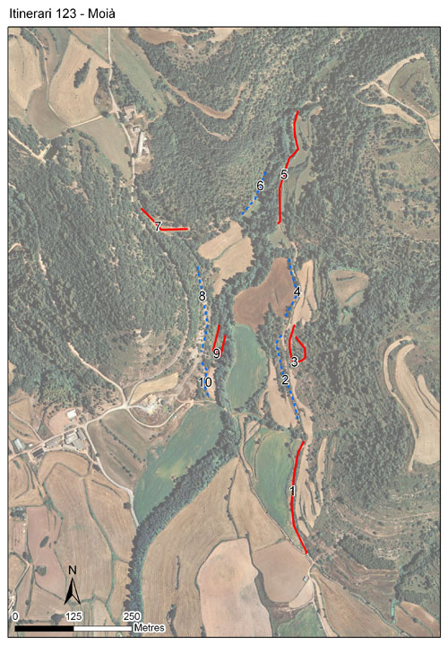
The map shows the transect route and the layout of the different sections. The background photograph corresponds to the 1:5000 orthophoto from the Cartographic Institute of Catalonia (ICGC).
Species occurring in this transect
Click to the Table to see the species list ordered by the abundance index average standardized at 100 m. Also, there is the trend each species follows in this itinerary. If you click the trend of any species you will enter Species by itinerary results. For more information about the index and trends calculation see Data analysis


Illustrations by Richard Lewington from Tolman & Lewington (1997) Butterflies of Britain and Europe, translated and published in Spanish by Lynx Edicions.
Change sheet
Characteristics
UTM10x10: 31T DG22, DG23
Province: Barcelona
County: Moianès
Municipality: Moià
Climatic region:
Mediterrani humit
Number of sections: 10
Total length: 1616 m
Average length: 161 m
Average altitude: 745 m
Participants: D Escalé, J Elias
Web map | Legal notes | Credits
Project in agreement with:


In collaboration with:

