122 - Puiggraciós
Aquest itinerari es troba al municipi del Figaró Montmany, al Vallès Oriental, tot i estar molt vinculat amb l'Ametlla del Vallès per on té el seu accés principal. Per iniciativa del Museu de Ciències Naturals de Granollers l'any 2012 entra a formar part de la xarxa oficial amb la Maria Guixé i l'Elisabet Martínez que han fet les observacions fins el 2013. L'any 2014 canvia l'observador.
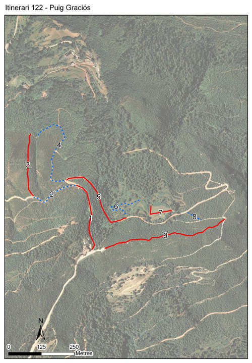
L'itinerari comença al peu del Santuari de la Mare de Déu de Puiggraciós. Aquest indret forma part del PEIN dels Cingles de Bertí, a la serralada Prelitoral, i va patir un dels pitjors incendis forestals de Catalunya l'any 1994 i aquest episodi marca en gran mesura el paisatge i les comunitats de bona part de l'itinerari. Aquest té una longitud de 2.281 metres dividits en 9 seccions, i es troba a una alçada mitjana de 644 metres.
Read more ...


Sampling and data series
Years with data: 14 [2012-2025] |
Climatic variables
Average annual temperature: 12 ºC |
Phenology
The bars show the weekly average butterfly abundance (calculated as the number of specimens per 1000 m) for the set of species recorded in the transect. Dots correspond to the weekly average number of species.
Habitats
The graph shows the relative cover of each habitat type in the whole transect. Since 2000, a botanical characterization has been performed for each itinerary every six years. For itineraries with more than one botanical characterization, you can change from one to another by clicking on the year of characterization.
Sections
The map shows the transect route and the layout of the different sections. The background photograph corresponds to the 1:5000 orthophoto from the Cartographic Institute of Catalonia (ICGC).
Species occurring in this transect
Click to the Table to see the species list ordered by the abundance index average standardized at 100 m. Also, there is the trend each species follows in this itinerary. If you click the trend of any species you will enter Species by itinerary results. For more information about the index and trends calculation see Data analysis


Illustrations by Richard Lewington from Tolman & Lewington (1997) Butterflies of Britain and Europe, translated and published in Spanish by Lynx Edicions.
Change sheet
Characteristics
UTM10x10: 31T DG31
Province: Barcelona
County: Vallès Oriental
Municipality: Figaró-Montmany
Climatic region:
Mediterrani humit
Number of sections: 9
Total length: 2281 m
Average length: 253 m
Average altitude: 643 m
Participants: M Guixé, T Arrizabalaga, E Martínez
Sponsors: Museu de Ciències Naturals de Granollers 
Web map | Legal notes | Credits
Project in agreement with:


In collaboration with:

