Aquesta web utiliza cookies tècniques, de personalització i anàlisi, pròpies i de tercers, per facilitar-li la navegació de forma anònima i analitzar estadístiques de l'ús de la web.
Considerem que, si continua navegant, n'accepta el seu ús. Obtenir més informació
i
Dard de taques blanques (Hesperia comma) - Pau Ortega i Colet
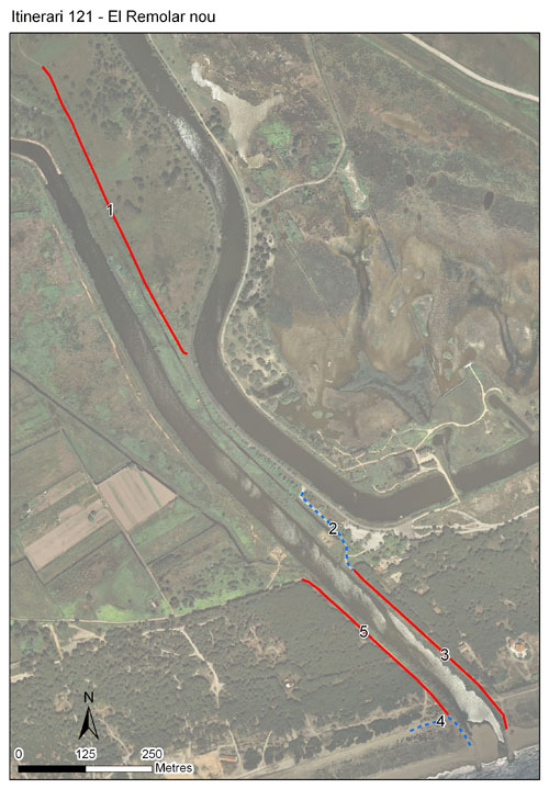
Situat a l’espai protegit del Delta del Llobregat, itinerari que substitueix l’anterior que hi transcorria en algunes de les seccions que el conformen. Té actualment 5 seccions, amb una longitud total de 1.725 metres i una alçada mitjana d'1 metre escàs, arribant a tocar la costa.
En atansar-se al mar, abasta les cadenes de vegetació que es disposen paral·lelament a la costa: pinedes litorals, vegetació de rereduna i vegetació de duna. Així mateix, recorre ambients azonals com la vora de l’estany del Remolar, i també mostreja ambients amb representació de vegetació ruderal i de prats mediterranis. Les seccions noves corresponen, bàsicament, a fenassars o a prats poc o molt higròfils, així com a retalls de boscos de ribera, sovint amb presència important d’espècies al·lòctones.
Sampling and data series
Years with data: 14 [2012-2025] Recorded species: 32 (Annual average: 24) Recorded individuals : 13399 (Annual average: 957) Number of recording samples: 358
Climatic variables
Average annual temperature: 16 ºC Average of January minima: 5 ºC Average of July maxima: 28 ºC Annual precipitation: 658 mm
Phenology
The bars show the weekly average butterfly abundance (calculated as the number of specimens per 1000 m) for the set of species recorded in the transect. Dots correspond to the weekly average number of species.
Habitats
The graph shows the relative cover of each habitat type in the whole transect. Since 2000, a botanical characterization has been performed for each itinerary every six years. For itineraries with more than one botanical characterization, you can change from one to another by clicking on the year of characterization.
2024
2018
2012
Sections
The map shows the transect route and the layout of the different sections. The background photograph corresponds to the 1:5000 orthophoto from the Cartographic Institute of Catalonia (ICGC).
Species occurring in this transect
Click to the Table to see the species list ordered by the abundance index average standardized at 100 m. Also, there is the trend each species follows in this itinerary. If you click the trend of any species you will enter Species by itinerary results. For more information about the index and trends calculation see Data analysis