12 - El Puig
L'itinerari del Puig està situat al Parc Natural del Montseny, entre el massís del Matagalls i el de Les Agudes. Els mostratges es van iniciar el 1994, el primer any del CBMS, i s'han mantingut ininterrompudament fins a l'actualitat. L'itinerari baixa per la vall on neix el riu Tordera, des de prop del coll de Sant Marçal fins a l'entorn del mas Els Terrers. Té una longitud de 2.017 m i 13 seccions, amb una mitjana de 155,2 m per secció.
Encara que la zona és eminentment forestal, amb un domini de la fageda, hi apareixen bones extensions d'espais oberts corresponents a les antigues feixes dels masos abans habitats (Sant Marçal, El Puig, Els Terrers). Aquestes feixes eren ocupades per conreus i prats de pastura i dall, que configuraven un mosaic amb una gran diversitat lepidopterològica. L'àrea conserva encara una gran riquesa de papallones, com ho demostren les 101 espècies detectades en les dues dècades de mostratges.
Read more ...

Sampling and data series
Years with data: 32 [1994-2025] |
Climatic variables
Average annual temperature: 10 ºC |
Phenology
The bars show the weekly average butterfly abundance (calculated as the number of specimens per 1000 m) for the set of species recorded in the transect. Dots correspond to the weekly average number of species.
Habitats
The graph shows the relative cover of each habitat type in the whole transect. Since 2000, a botanical characterization has been performed for each itinerary every six years. For itineraries with more than one botanical characterization, you can change from one to another by clicking on the year of characterization.
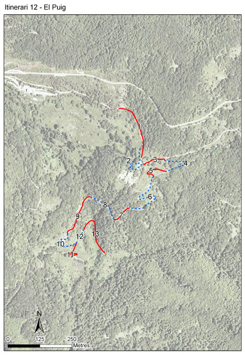
Sections
The map shows the transect route and the layout of the different sections. The background photograph corresponds to the 1:5000 orthophoto from the Cartographic Institute of Catalonia (ICGC).
Species occurring in this transect
Click to the Table to see the species list ordered by the abundance index average standardized at 100 m. Also, there is the trend each species follows in this itinerary. If you click the trend of any species you will enter Species by itinerary results. For more information about the index and trends calculation see Data analysis


Illustrations by Richard Lewington from Tolman & Lewington (1997) Butterflies of Britain and Europe, translated and published in Spanish by Lynx Edicions.
Change sheet
Characteristics
UTM10x10: 31T DG52
Province: Barcelona
County: Vallès Oriental
Municipality: Montseny
Protected area: Massís del Montseny
Climatic region:
Alpí i subalpí
Number of sections: 13
Total length: 2017 m
Average length: 155 m
Average altitude: 1033 m
Participants: C Stefanescu
Sponsors: DIBA - PN Montseny 
Web map | Legal notes | Credits
Project in agreement with:


In collaboration with:

