117 - Planes de Son
Situat dins de la zona perifèrica de protecció del Parc Nacional d’Aigüestortes i Estany de Sant Maurici, al municipi de l’Alt Àneu. Té 10 seccions amb una longitud total de 1.493 metres i es troba situat a una alçada mitjana de 1.556 metres. Els comptatges es realitzen des de l’any 2011 ininterrompudament.
Itinerari que recorre l’entorn del centre de natura de Planes de Son, en un ambient típic pirinenc dominat per prats i herbassars i, en alguna secció, bosc subalpí. Hi són ben representats els prats de dall i pastures de Bromion, així com herbassars higròfils.


Sampling and data series
Years with data: 15 [2011-2025] |
Climatic variables
Average annual temperature: --- |
Phenology
The bars show the weekly average butterfly abundance (calculated as the number of specimens per 1000 m) for the set of species recorded in the transect. Dots correspond to the weekly average number of species.
Habitats
The graph shows the relative cover of each habitat type in the whole transect. Since 2000, a botanical characterization has been performed for each itinerary every six years. For itineraries with more than one botanical characterization, you can change from one to another by clicking on the year of characterization.
Sections
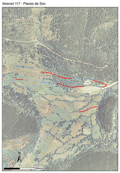
The map shows the transect route and the layout of the different sections. The background photograph corresponds to the 1:5000 orthophoto from the Cartographic Institute of Catalonia (ICGC).
Species occurring in this transect
Click to the Table to see the species list ordered by the abundance index average standardized at 100 m. Also, there is the trend each species follows in this itinerary. If you click the trend of any species you will enter Species by itinerary results. For more information about the index and trends calculation see Data analysis


Illustrations by Richard Lewington from Tolman & Lewington (1997) Butterflies of Britain and Europe, translated and published in Spanish by Lynx Edicions.
Change sheet
Characteristics
UTM10x10: 31T CH42
Province: Lleida
County: Pallars Sobirà
Municipality: Alt Àneu
Climatic region:
Alpí i subalpí
Number of sections: 10
Total length: 1493 m
Average length: 149 m
Average altitude: 1556 m
Participants: F Rodríguez, M Ballbè
Sponsors: Fundació Catalunya Caixa (2011-2014), Parc Nacional d'Aigüestortes i Estany de Sant Maurici 
Web map | Legal notes | Credits
Project in agreement with:


In collaboration with:

