Aquesta web utiliza cookies tècniques, de personalització i anàlisi, pròpies i de tercers, per facilitar-li la navegació de forma anònima i analitzar estadístiques de l'ús de la web.
Considerem que, si continua navegant, n'accepta el seu ús. Obtenir més informació
i
Griseta mediterrània (Lysandra hispana) - Pau Ortega i Colet
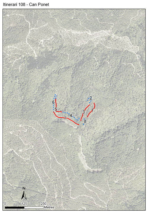
L’itinerari de can Ponet es fa al voltant del mas homònim, que es troba situat al veïnat de Sant Martí de Montnegre, al bell mig del Parc del Montnegre i el Corredor. Es duu a terme des de l’any 2008, i té un recorregut de 8 seccions amb una llargada total de 968 metres, recorrent les feixes a l’entorn del mas, així com els boscos de la zona: suredes, alzinars i perxades de castanyers.
Una de les singularitats de l’itinerari de can Ponet és que haurà de permetre constatar els canvis en les poblacions de lepidòpters a mesura que es recuperin els espais oberts del mas, alhora que es podran comparar amb l’altra meitat de l’itinerari, la qual, a priori, no ho ha d’experimentar.
Es troba situat dalt d’un turó dominat per la sureda, tot i que la cota mitjana i la variació d’exposicions permet que apareguin boscos eurosiberians. L’esponera forestal del Montnegre, però, fa que sigui un itinerari encara poc ric en espècies (una mitjana de 30 espècies l’any) i amb una disminució marcada els mesos estivals a causa de l’eixut mediterrani.
Sampling and data series
Years with data: 18 [2008-2025] Recorded species: 51 (Annual average: 30) Recorded individuals : 5835 (Annual average: 324) Number of recording samples: 520
Climatic variables
Average annual temperature: 14 ºC Average of January minima: 2 ºC Average of July maxima: 28 ºC Annual precipitation: 869 mm
Phenology
The bars show the weekly average butterfly abundance (calculated as the number of specimens per 1000 m) for the set of species recorded in the transect. Dots correspond to the weekly average number of species.
Habitats
The graph shows the relative cover of each habitat type in the whole transect. Since 2000, a botanical characterization has been performed for each itinerary every six years. For itineraries with more than one botanical characterization, you can change from one to another by clicking on the year of characterization.
2025
2018
2011
2010
2009
2008
Sections
The map shows the transect route and the layout of the different sections. The background photograph corresponds to the 1:5000 orthophoto from the Cartographic Institute of Catalonia (ICGC).
Species occurring in this transect
Click to the Table to see the species list ordered by the abundance index average standardized at 100 m. Also, there is the trend each species follows in this itinerary. If you click the trend of any species you will enter Species by itinerary results. For more information about the index and trends calculation see Data analysis