Aquesta web utiliza cookies tècniques, de personalització i anàlisi, pròpies i de tercers, per facilitar-li la navegació de forma anònima i analitzar estadístiques de l'ús de la web.
Considerem que, si continua navegant, n'accepta el seu ús. Obtenir més informació
i
Dard de taques blanques (Hesperia comma) - Pau Ortega i Colet
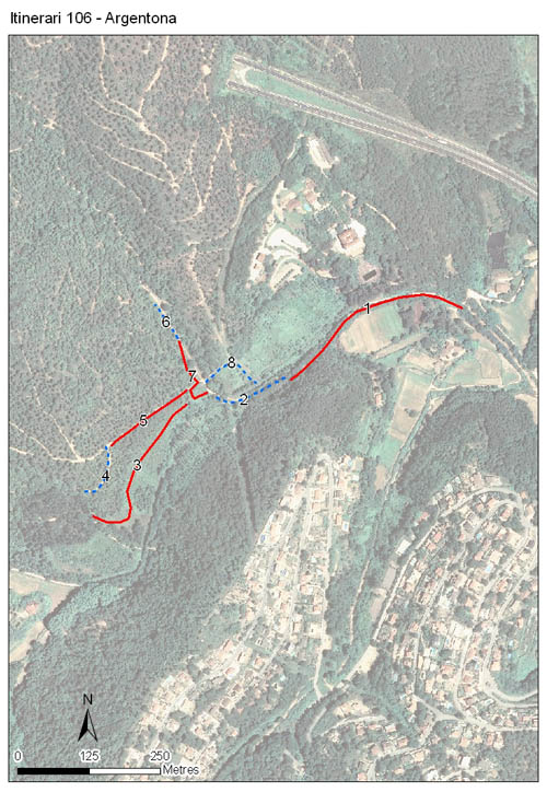
Situat en el Parc de la Serralada Litoral, just al seu límit nord, a uns 7,5 km de la costa, recorrent una vall paral·lela a aquesta. La seva longitud total és de 1.412 metres i està dividit en 8 seccions, amb una mitjana de 176 metres per secció, i l'alçada mitjana és de 134 metres. Els comptatges es van iniciar el 2008, mantenint-se ininterrompudament fins a l'actualitat.
El sòl és silícic, dominat pel característic sauló del Maresme, i el recorregut segueix inicialment el marge de la riera per després enfilar-se pel seu vessant nord.
Resseguint la riera creix una vegetació de ribera de tipus termòfil amb alocars, lloredes i omedes. Després l'itinerari travessa un alzinar que havia estat tallat poc abans d'iniciar els comptatges i que ara creix ràpidament. Al enfilar-se pel vessant nord es passa per pinedes mixtes de pi blanc, pi pinyer i pinastre amb força alzines, i un sotabosc compost per una brolla d'estepes i romaní. A la part final dominen les bardisses de roldor i esbarzer.
Years with data: 18 [2008-2025] Recorded species: 67 (Annual average: 49) Recorded individuals : 30029 (Annual average: 1668) Number of recording samples: 510
Climatic variables
Average annual temperature: 15 ºC Average of January minima: 3 ºC Average of July maxima: 29 ºC Annual precipitation: 653 mm
Phenology
The bars show the weekly average butterfly abundance (calculated as the number of specimens per 1000 m) for the set of species recorded in the transect. Dots correspond to the weekly average number of species.
Habitats
The graph shows the relative cover of each habitat type in the whole transect. Since 2000, a botanical characterization has been performed for each itinerary every six years. For itineraries with more than one botanical characterization, you can change from one to another by clicking on the year of characterization.
2020
2014
2008
Sections
The map shows the transect route and the layout of the different sections. The background photograph corresponds to the 1:5000 orthophoto from the Cartographic Institute of Catalonia (ICGC).
Species occurring in this transect
Click to the Table to see the species list ordered by the abundance index average standardized at 100 m. Also, there is the trend each species follows in this itinerary. If you click the trend of any species you will enter Species by itinerary results. For more information about the index and trends calculation see Data analysis