Aquesta web utiliza cookies tècniques, de personalització i anàlisi, pròpies i de tercers, per facilitar-li la navegació de forma anònima i analitzar estadístiques de l'ús de la web.
Considerem que, si continua navegant, n'accepta el seu ús. Obtenir més informació
i
Daurat de punta taronja (Thymelicus sylvestris) - Pau Ortega i Colet
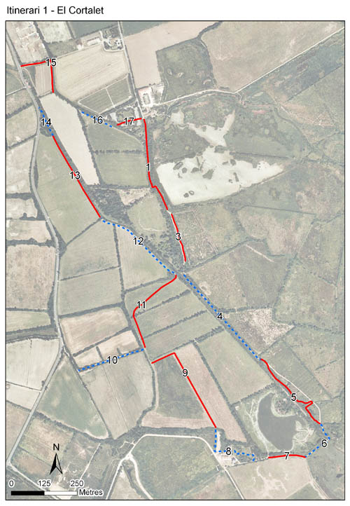
L’itinerari del Cortalet està situat al Parc Natural dels Aiguamolls de l’Empordà, dins l’anomenat polígon 2 d’aquest espai natural, a una distància mitjana del mar de 1.772 m. Els comptatges es van iniciar l’any 1988 i, tret del 1990, s’han realitzat ininterrompudament fins ara. El recorregut és circular i consta de 16 seccions, després que la secció 2 desaparegués el 1989 amb la creació de l’estany del Cortalet. La distància total és de 4.297 m, amb una mitjana de 269 m per secció (rang: 94-437 m).
La zona ofereix una mostra dels paisatges més típics de la plana empordanesa. Hi ha, per exemple, una bona presència de closes (prats de pastura o dall envoltats per tanques d’oms, freixes i roures) i camins que voregen recs de desguàs amb bosc de ribera. Així mateix, la part de l’itinerari no inclosa dins la Reserva Integral travessa una extensa àrea agrícola.
Years with data: 34 [1988,1993-2025] Recorded species: 57 (Annual average: 32) Recorded individuals : 156057 (Annual average: 4590) Number of recording samples: 890
Climatic variables
Average annual temperature: 15 ºC Average of January minima: 4 ºC Average of July maxima: 28 ºC Annual precipitation: 627 mm
Phenology
The bars show the weekly average butterfly abundance (calculated as the number of specimens per 1000 m) for the set of species recorded in the transect. Dots correspond to the weekly average number of species.
Habitats
The graph shows the relative cover of each habitat type in the whole transect. Since 2000, a botanical characterization has been performed for each itinerary every six years. For itineraries with more than one botanical characterization, you can change from one to another by clicking on the year of characterization.
2024
2018
2012
2006
2000
Sections
The map shows the transect route and the layout of the different sections. The background photograph corresponds to the 1:5000 orthophoto from the Cartographic Institute of Catalonia (ICGC).
Species occurring in this transect
Click to the Table to see the species list ordered by the abundance index average standardized at 100 m. Also, there is the trend each species follows in this itinerary. If you click the trend of any species you will enter Species by itinerary results. For more information about the index and trends calculation see Data analysis