85 - Gerri de la Sal
Situat al sud de la comarca del Pallars Sobirà, a una alçada de 592 metres. És un itinerari de 10 seccions amb una longitud total de 1.468 metres. S’ha realitzat durant tres períodes diferents, amb diferents mostrejadors, els anys 2006-2010, 2014-2017, reprenent els comptatges l'any 2019.
Es troba dins de l’ambient de la muntanya mitjana plujosa submediterrània, dominat per rouredes i pinedes muntanyenques seques. Hi ha predominància de prats montans, però també recorre matolls i roquissars. La zona és d’una riquesa lepidopterològica excepcional, essent l'itinerari amb més diversitat d’espècies de tota la xarxa del CBMS.
[Sampling and data series]
[Years with data]: 16 [2006-2010,2014-2017,2019-2025] |
[Climatic variables]
[Average annual temperature]: 12 ºC |
[Phenology]
[The bars show the weekly average butterfly abundance (calculated as the number of specimens per 1000 m) for the set of species recorded in the transect. Dots correspond to the weekly average number of species.]
[Habitats]
[The graph shows the relative cover of each habitat type in the whole transect. Since 2000, a botanical characterization has been performed for each itinerary every six years. For itineraries with more than one botanical characterization, you can change from one to another by clicking on the year of characterization.]
Secciones
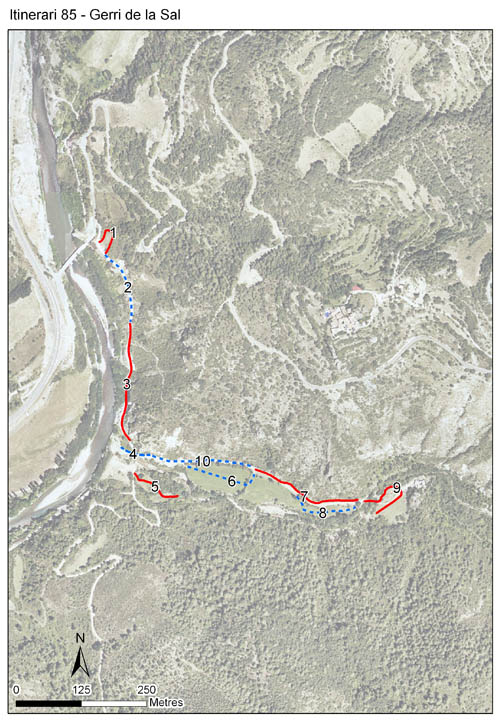
[The map shows the transect route and the layout of the different sections. The background photograph corresponds to the 1:5000 orthophoto from the Cartographic Institute of Catalonia (ICGC).]
[Species occurring in this transect]
[Click to the Table to see the species list ordered by the abundance index average standardized at 100 m. Also, there is the trend each species follows in this itinerary. If you click the trend of any species you will enter Species by itinerary results. For more information about the index and trends calculation see Data analysis]


[Illustrations by Richard Lewington from Tolman & Lewington (1997) Butterflies of Britain and Europe, translated and published in Spanish by Lynx Edicions.]
[Change sheet]
[Characteristics]
[UTM10x10]: 31T CG48
[Province]: Lleida
[County]: Pallars Sobirà
Municipio: Baix Pallars
[Climatic region]:
Mediterrani humit
Número de secciones: 10
[Total length]: 1468 m
[Average length]: 146 m
[Average altitude]: 593 m
Participantes: M Avizanda, P Martínez, J Piqué, M Gómez, B Font
[Web map] | [Notes legals] | Créditos
[Project in agreement with:]


En colaboración con:

