Aquesta web utiliza cookies tècniques, de personalització i anàlisi, pròpies i de tercers, per facilitar-li la navegació de forma anònima i analitzar estadístiques de l'ús de la web.
Considerem que, si continua navegant, n'accepta el seu ús. Obtenir més informació
i
Damer rogenc (Melitaea didyma) - Pau Ortega i Colet
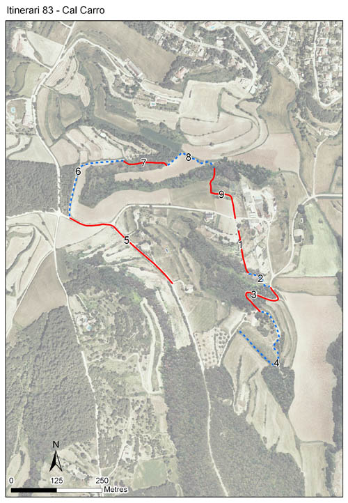
Situat a la plana vallesana propera al Parc Natural del Montseny, al municipi de Cardedeu. Té un total de 9 seccions. Una longitud total de 1.794 metres i es troba a una alçada mitjana de 306 metres. Els comptatges es van realitzar els anys 2005 i 2006, recuperant-se l’any 2019.
Es troba en una zona agrícola i forestal, representativa dels ambients de la plana vallesana. Està conformat així en un mosaic on apareixen espècies típiques de zones montanes i altres de conreus de terra baixa.
[Average annual temperature]: 14 ºC [Average of January minima]: 1 ºC [Average of July maxima]: 28 ºC [Annual precipitation]: 741 mm
[Phenology]
[The bars show the weekly average butterfly abundance (calculated as the number of specimens per 1000 m) for the set of species recorded in the transect. Dots correspond to the weekly average number of species.]
[Habitats]
[The graph shows the relative cover of each habitat type in the whole transect. Since 2000, a botanical characterization has been performed for each itinerary every six years. For itineraries with more than one botanical characterization, you can change from one to another by clicking on the year of characterization.]
2021
2006
Secciones
[The map shows the transect route and the layout of the different sections. The background photograph corresponds to the 1:5000 orthophoto from the Cartographic Institute of Catalonia (ICGC).]
[Species occurring in this transect]
[Click to the Table to see the species list ordered by the abundance index average standardized at 100 m. Also, there is the trend each species follows in this itinerary. If you click the trend of any species you will enter Species by itinerary results. For more information about the index and trends calculation see Data analysis]