Aquesta web utiliza cookies tècniques, de personalització i anàlisi, pròpies i de tercers, per facilitar-li la navegació de forma anònima i analitzar estadístiques de l'ús de la web.
Considerem que, si continua navegant, n'accepta el seu ús. Obtenir més informació
i
Dard de taques blanques (Hesperia comma) - Pau Ortega i Colet
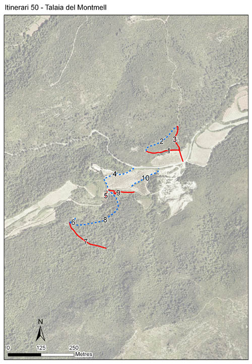
Localitzat al municipi de Montmell, al Baix Penedès, al peu del punt culminal del massís del Montmell. Té una alçada de 628,4 m , una longitud total de 1.367 m, amb 10 seccions i 136 m de mitjana per secció. L’itinerari es va realitzar tan sols durant dos anys, el 2001 i el 2002.
Es troba en una zona de pinedes de pi blanc, amb fenassars, joncedes i garrigues. És clarament un ambient de dominància d’ecosistemes mediterranis, amb prats, matollars, boscos i ambients ruderals.
[Average annual temperature]: 13 ºC [Average of January minima]: 2 ºC [Average of July maxima]: 27 ºC [Annual precipitation]: 709 mm
[Phenology]
[The bars show the weekly average butterfly abundance (calculated as the number of specimens per 1000 m) for the set of species recorded in the transect. Dots correspond to the weekly average number of species.]
[Habitats]
[The graph shows the relative cover of each habitat type in the whole transect. Since 2000, a botanical characterization has been performed for each itinerary every six years. For itineraries with more than one botanical characterization, you can change from one to another by clicking on the year of characterization.]
2001
Secciones
[The map shows the transect route and the layout of the different sections. The background photograph corresponds to the 1:5000 orthophoto from the Cartographic Institute of Catalonia (ICGC).]
[Species occurring in this transect]
[Click to the Table to see the species list ordered by the abundance index average standardized at 100 m. Also, there is the trend each species follows in this itinerary. If you click the trend of any species you will enter Species by itinerary results. For more information about the index and trends calculation see Data analysis]