29 - Marata
Aquest itinerari es troba al municipi de les Franqueses del Vallès, al Vallès Oriental, i fa el seu recorregut entre les parròquies de Marata i Corró d'Amunt. Per iniciativa del Museu de Ciències Naturals de Granollers, des de l'any 1997 forma part de la xarxa del CBMS; l'estació s'ha mantingut activa ininterrompudament, tot i que els observadors han canviat en dues ocasions.
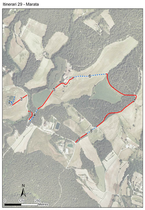
L'itinerari comença a la llera de la riera de Carbonell, afluent del Congost, que recull aigües des de les immediacions de la Calma, al Montseny. Travessa diverses finques agràries amb el paisatge típic del Vallès sobre la plana miocènica: una ondulació del terreny produïda per l'efecte de les diverses rieres secundàries que la travessen de nord a sud. Té una longitud de 2.030 m i està dividit en 9 seccions.
Leer más ...


[Sampling and data series]
[Years with data]: 29 [1997-2025] |
[Climatic variables]
[Average annual temperature]: 14 ºC |
[Phenology]
[The bars show the weekly average butterfly abundance (calculated as the number of specimens per 1000 m) for the set of species recorded in the transect. Dots correspond to the weekly average number of species.]
[Habitats]
[The graph shows the relative cover of each habitat type in the whole transect. Since 2000, a botanical characterization has been performed for each itinerary every six years. For itineraries with more than one botanical characterization, you can change from one to another by clicking on the year of characterization.]
Secciones
[The map shows the transect route and the layout of the different sections. The background photograph corresponds to the 1:5000 orthophoto from the Cartographic Institute of Catalonia (ICGC).]
[Species occurring in this transect]
[Click to the Table to see the species list ordered by the abundance index average standardized at 100 m. Also, there is the trend each species follows in this itinerary. If you click the trend of any species you will enter Species by itinerary results. For more information about the index and trends calculation see Data analysis]


[Illustrations by Richard Lewington from Tolman & Lewington (1997) Butterflies of Britain and Europe, translated and published in Spanish by Lynx Edicions.]
[Change sheet]
[Characteristics]
[UTM10x10]: 31T DG41
[Province]: Barcelona
[County]: Vallès Oriental
Municipio: les Franqueses del Vallès
[Climatic region]:
Mediterrani humit
Número de secciones: 9
[Total length]: 2030 m
[Average length]: 225 m
[Average altitude]: 265 m
Participantes: O Alcaide, S Prat, J Sardanyés, T Arrizabalaga, M Pujolàs
[Sponsors]: Museu de Ciències Naturals de Granollers (1997-2009)
[Web map] | [Notes legals] | Créditos
[Project in agreement with:]


En colaboración con:

