151 - Castelltallat
Itinerari de baix esforç, situat a la comarca del Bages, dins l'espai protegit de la Serra de Castelltallat. Es tracta d'un itinerari llarg, de 2.062 metres divisit en 9 seccions, que es realitza des de l’any 2017. Es troba a una alçada de 780 metres.
El recorregut és eminentment forestal amb predomini de boscos de coníferes montans i matollars alts, però també inclou un sistema de prats de pastura que li donen molta més diversitat.

- Cynthia 17, [page] 20 Castelltallat, un espai forestal al centre de Catalunya amb impactes importants per l’abandonament i el foc
[References to Cynthia magazine]
[Sampling and data series]
[Years with data]: 9 [2017-2025] |
[Climatic variables]
[Average annual temperature]: 11 ºC |
[Phenology]
[The bars show the weekly average butterfly abundance (calculated as the number of specimens per 1000 m) for the set of species recorded in the transect. Dots correspond to the weekly average number of species.]
[Habitats]
[The graph shows the relative cover of each habitat type in the whole transect. Since 2000, a botanical characterization has been performed for each itinerary every six years. For itineraries with more than one botanical characterization, you can change from one to another by clicking on the year of characterization.]
Secciones
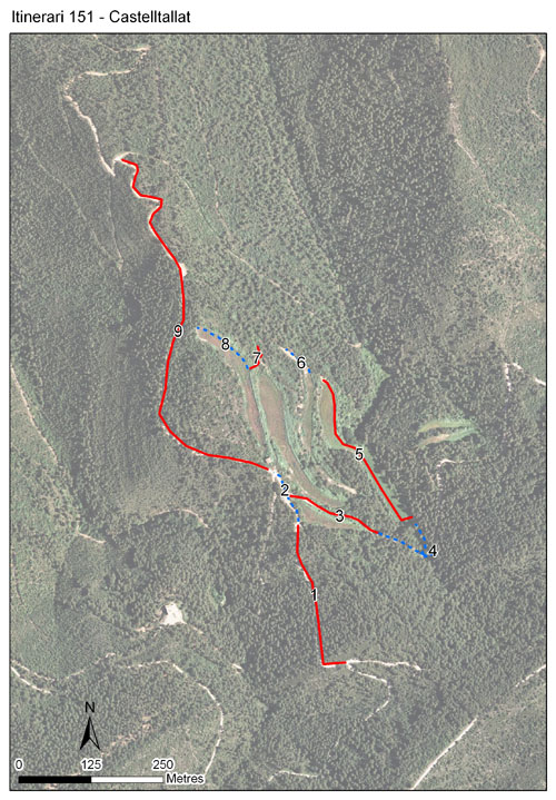
[The map shows the transect route and the layout of the different sections. The background photograph corresponds to the 1:5000 orthophoto from the Cartographic Institute of Catalonia (ICGC).]
[Species occurring in this transect]
[Click to the Table to see the species list ordered by the abundance index average standardized at 100 m. Also, there is the trend each species follows in this itinerary. If you click the trend of any species you will enter Species by itinerary results. For more information about the index and trends calculation see Data analysis]


[Illustrations by Richard Lewington from Tolman & Lewington (1997) Butterflies of Britain and Europe, translated and published in Spanish by Lynx Edicions.]
[Change sheet]
[Characteristics]
[UTM10x10]: 31T CG82, CG83
[Province]: Barcelona
[County]: Bages
Municipio: Sant Mateu de Bages
[Protected area]: Serra de Castelltallat
[Climatic region]:
Mediterrani humit
Número de secciones: 9
[Total length]: 2062 m
[Average length]: 229 m
[Average altitude]: 780 m
Participantes: J Planes
[Web map] | [Notes legals] | Créditos
[Project in agreement with:]


En colaboración con:

