Aquesta web utiliza cookies tècniques, de personalització i anàlisi, pròpies i de tercers, per facilitar-li la navegació de forma anònima i analitzar estadístiques de l'ús de la web.
Considerem que, si continua navegant, n'accepta el seu ús. Obtenir més informació
i
Daurat de punta taronja (Thymelicus sylvestris) - Pau Ortega i Colet
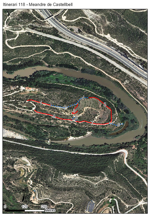
L’itinerari del meandre de Castellbell es troba en el corredor natural que rep aquest mateix nom, i que connecta els parcs naturals de Montserrat i de Sant Llorenç del Munt i l'Obac. L’itinerari, que té una longitud total de 1.145 m, consta de 9 seccions en un recorregut circular que envolta la plana agrícola del meandre situada sota el castell de Castellbell. Aquest itinerari va estar actiu des de l’any 2011 al 2021, exceptuant els anys 2017 i 2018 que van quedar en blanc.
La composició i la distribució de la vegetació es veuen clarament afectades per la seva anterior condició de zona d’ús agrícola, actualment abandonada, pel que mescla espècies agrícoles i ruderals amb comunitats pròpies de diferents estadis del procés de recolonització, com ara timonedes, brolles de romaní amb bufalaga tintòria, i boscos mixtes de pi blanc i alzina amb marfull. L’itinerari passa per fruiterars de secà abandonats, recorrent també algunes seccions de caràcter forestal i de vegetació d’ambient fluvial.
[Average annual temperature]: 15 ºC [Average of January minima]: 2 ºC [Average of July maxima]: 30 ºC [Annual precipitation]: 563 mm
[Phenology]
[The bars show the weekly average butterfly abundance (calculated as the number of specimens per 1000 m) for the set of species recorded in the transect. Dots correspond to the weekly average number of species.]
[Habitats]
[The graph shows the relative cover of each habitat type in the whole transect. Since 2000, a botanical characterization has been performed for each itinerary every six years. For itineraries with more than one botanical characterization, you can change from one to another by clicking on the year of characterization.]
2024
2019
2012
Secciones
[The map shows the transect route and the layout of the different sections. The background photograph corresponds to the 1:5000 orthophoto from the Cartographic Institute of Catalonia (ICGC).]
[Species occurring in this transect]
[Click to the Table to see the species list ordered by the abundance index average standardized at 100 m. Also, there is the trend each species follows in this itinerary. If you click the trend of any species you will enter Species by itinerary results. For more information about the index and trends calculation see Data analysis]