165 - Els Plaus
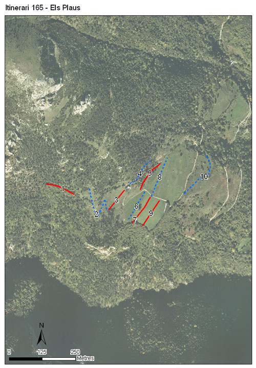
Itinerari situat a la reserva nacional de caça Freser-Setcases, al municipi de Queralbs, comarca del Ripollès. Té un total de 10 seccions, una longitud de 1.382 metres i es troba situat a una alçada mitjana de 1.506 metres. S'hi realitzen comptatges des del 2019.
El recorregut passa per la zona on abunden prats de pastura en alçada, calcícoles i mesòfils, i també prats de dall. Es tracta d'un espai amb pendent i el circumden zones de pi roig, boixeda i avellanosa.

[Sampling and data series]
[Years with data]: 7 [2019-2025] |
[Climatic variables]
[Average annual temperature]: 8 ºC |
[Phenology]
[The bars show the weekly average butterfly abundance (calculated as the number of specimens per 1000 m) for the set of species recorded in the transect. Dots correspond to the weekly average number of species.]
[Habitats]
[The graph shows the relative cover of each habitat type in the whole transect. Since 2000, a botanical characterization has been performed for each itinerary every six years. For itineraries with more than one botanical characterization, you can change from one to another by clicking on the year of characterization.]
Secciones
[The map shows the transect route and the layout of the different sections. The background photograph corresponds to the 1:5000 orthophoto from the Cartographic Institute of Catalonia (ICGC).]
[Species occurring in this transect]
[Click to the Table to see the species list ordered by the abundance index average standardized at 100 m. Also, there is the trend each species follows in this itinerary. If you click the trend of any species you will enter Species by itinerary results. For more information about the index and trends calculation see Data analysis]


[Illustrations by Richard Lewington from Tolman & Lewington (1997) Butterflies of Britain and Europe, translated and published in Spanish by Lynx Edicions.]
[Change sheet]
[Characteristics]
[UTM10x10]: 31T DG28
[Province]: Girona
[County]: Ripollès
Municipio: Queralbs
[Climatic region]:
Alpí i subalpí
Número de secciones: 10
[Total length]: 1382 m
[Average length]: 138 m
[Average altitude]: 1505 m
Participantes: A de Jorge, A Planella, I Figueroa, G Mas, B Font
[Sponsors]: Associació Paisatges Vius, Museu de Ciències Naturals de Granollers 

[Web map] | [Notes legals] | Créditos
[Project in agreement with:]


En colaboración con:

