164 - Montsagre
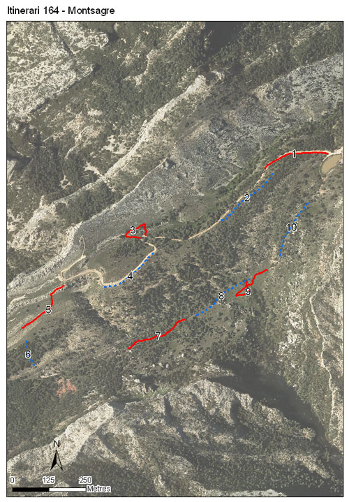
Estació situada al Parc Natural dels Ports, entre els municipis d'Horta de Sant Joan, Paüls i Prats del Compte, al Baix Ebre- Terra Alta. Està composat per 10 seccions, té una longitud total de 2.113 metres i es troba a una alçada mitjana de 933 metres. Els comptatges es realitzen des del 2019.
El recorregut transcorre joncedes montanes, timonedes mes aviat mediterrànies i prats de fenàs i llistó. També hi són presents savinoses, boscos de pinassa i cadequers, entre altres comunitats vegetals.


[Sampling and data series]
[Years with data]: 5 [2019-2023] |
[Climatic variables]
[Average annual temperature]: 12 ºC |
[Phenology]
[The bars show the weekly average butterfly abundance (calculated as the number of specimens per 1000 m) for the set of species recorded in the transect. Dots correspond to the weekly average number of species.]
[Habitats]
[The graph shows the relative cover of each habitat type in the whole transect. Since 2000, a botanical characterization has been performed for each itinerary every six years. For itineraries with more than one botanical characterization, you can change from one to another by clicking on the year of characterization.]
Secciones
[The map shows the transect route and the layout of the different sections. The background photograph corresponds to the 1:5000 orthophoto from the Cartographic Institute of Catalonia (ICGC).]
[Species occurring in this transect]
[Click to the Table to see the species list ordered by the abundance index average standardized at 100 m. Also, there is the trend each species follows in this itinerary. If you click the trend of any species you will enter Species by itinerary results. For more information about the index and trends calculation see Data analysis]


[Illustrations by Richard Lewington from Tolman & Lewington (1997) Butterflies of Britain and Europe, translated and published in Spanish by Lynx Edicions.]
[Change sheet]
[Characteristics]
[UTM10x10]: 31T BF73
[Province]: Tarragona
[County]: Baix Ebre, Terra Alta
Municipio: Horta de Sant Joan, Paüls, Prat de Comte
[Protected area]: Parc Natural dels Ports
[Climatic region]:
Mediterrani humit
Número de secciones: 10
[Total length]: 2113 m
[Average length]: 211 m
[Average altitude]: 932 m
Participantes: M Huguet, I Monsonís
[Sponsors]: PN dels Ports 
[Web map] | [Notes legals] | Créditos
[Project in agreement with:]


En colaboración con:

