167 - Toirigo
Itinerari situat al terme municipal de la Vall de Boí, dins del Parc Nacional d'Aigüestortes, a la comarca de l'Alta Ribagorça. Té una longitud total de 1.491 metres dividits en 8 seccions, a una alçada mitjana de 1.509 metres. Es va incorporar a la xarxa del CBMS l'any 2019.
El recorregut transcorre majoritàriament per prats montans de pastura intercalats entre matollars baixos de boix i amb algun tram de bosc mixt de caducifolis amb avet i pi roig. Conté també un parell de petites zones humides de muntanya molt interessants.


[Sampling and data series]
[Years with data]: 5 [2019-2023] |
[Climatic variables]
[Average annual temperature]: 7 ºC |
[Phenology]
[The bars show the weekly average butterfly abundance (calculated as the number of specimens per 1000 m) for the set of species recorded in the transect. Dots correspond to the weekly average number of species.]
[Habitats]
[The graph shows the relative cover of each habitat type in the whole transect. Since 2000, a botanical characterization has been performed for each itinerary every six years. For itineraries with more than one botanical characterization, you can change from one to another by clicking on the year of characterization.]
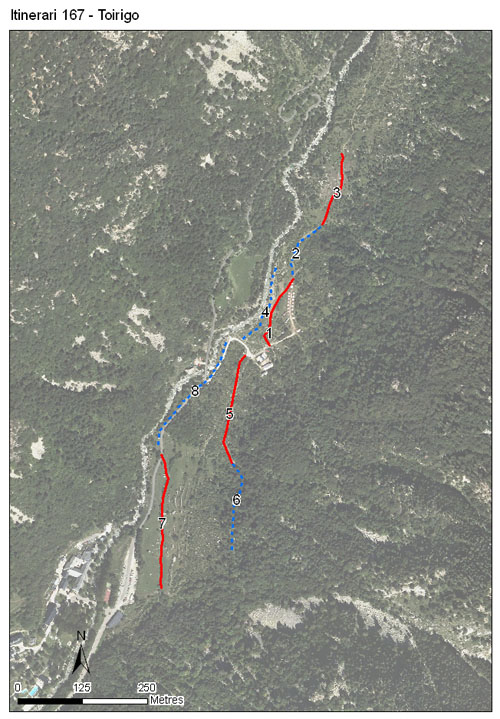
Secciones
[The map shows the transect route and the layout of the different sections. The background photograph corresponds to the 1:5000 orthophoto from the Cartographic Institute of Catalonia (ICGC).]
[Species occurring in this transect]
[Click to the Table to see the species list ordered by the abundance index average standardized at 100 m. Also, there is the trend each species follows in this itinerary. If you click the trend of any species you will enter Species by itinerary results. For more information about the index and trends calculation see Data analysis]


[Illustrations by Richard Lewington from Tolman & Lewington (1997) Butterflies of Britain and Europe, translated and published in Spanish by Lynx Edicions.]
[Change sheet]
[Characteristics]
[UTM10x10]: 31T CH21
[Province]: Lleida
[County]: Alta Ribagorça
Municipio: la Vall de Boí
[Protected area]: Zona perifèrica de protecció del Parc Nacional d'Aigüestortes i Estany de Sant Maurici
[Climatic region]:
Alpí i subalpí
Número de secciones: 8
[Total length]: 1491 m
[Average length]: 186 m
[Average altitude]: 1509 m
Participantes: J Santos, M Farré
[Sponsors]: Parc Nacional d'Aigüestortes i Estany de Sant Maurici 
[Web map] | [Notes legals] | Créditos
[Project in agreement with:]


En colaboración con:

