Aquesta web utiliza cookies tècniques, de personalització i anàlisi, pròpies i de tercers, per facilitar-li la navegació de forma anònima i analitzar estadístiques de l'ús de la web.
Considerem que, si continua navegant, n'accepta el seu ús. Obtenir més informació
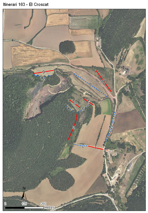
Itinerari situat al Parc Natural de la Zona Volcànica de la Garrotxa, entre els municipis d'Olot i Santa Pau. Consta de 12 seccions, una longitud total de 1.592 metres i es troba a una alçada mitjana de 626 metres. Es va iniciar l'any 2019.
Situat al vessant nord-est de l'emblemàtic volcà Croscat, en una zona on abunden prats de pastura montans ben conservats. El recorregut passa també per un tram d'alzinar i camins ruderals de la zona.
[Average annual temperature]: 12 ºC [Average of January minima]: -1 ºC [Average of July maxima]: 27 ºC [Annual precipitation]: 1117 mm
[Phenology]
[The bars show the weekly average butterfly abundance (calculated as the number of specimens per 1000 m) for the set of species recorded in the transect. Dots correspond to the weekly average number of species.]
[Habitats]
[The graph shows the relative cover of each habitat type in the whole transect. Since 2000, a botanical characterization has been performed for each itinerary every six years. For itineraries with more than one botanical characterization, you can change from one to another by clicking on the year of characterization.]
2019
Secciones
[The map shows the transect route and the layout of the different sections. The background photograph corresponds to the 1:5000 orthophoto from the Cartographic Institute of Catalonia (ICGC).]
[Species occurring in this transect]
[Click to the Table to see the species list ordered by the abundance index average standardized at 100 m. Also, there is the trend each species follows in this itinerary. If you click the trend of any species you will enter Species by itinerary results. For more information about the index and trends calculation see Data analysis]